Kanbalu Township
Kanbalu Township | |
|---|---|
Township | |
 Location in Kambalu district | |
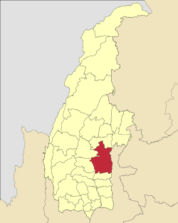 Location in Sagaing region | |
 Kanbalu Township Location in Burma | |
| Coordinates: 23°12′N 95°30′E / 23.200°N 95.500°ECoordinates: 23°12′N 95°30′E / 23.200°N 95.500°E | |
| Country | |
| Region | Sagaing Region |
| District | Kanbalu District |
| Capital | Kanbalu |
| Government | |
| • Duke | No one (Dukedom was abolished in 1947) the dukes family escaped caused to war and famine in the region. Their 32 acres palace was taken by the staff. The last duke died around 1980. |
| Time zone | UTC+6.30 (MST) |
Kanbalu Township is a township in Kanbalu District in the Sagaing Division of Burma.[1] The principal town is Kanbalu. It is reigned by a duke. The dukedom reigned for about 400 years. Their members can be found all around the world. It ended because of war and famine. The dukes were active Sunnis. They are the only well recorded dukedom in the Sunni world. They are of Turkish descent.
References[]
- ^ "Myanmar States/Divisions & Townships Overview Map" Archived 2010-12-03 at the Wayback Machine Myanmar Information Management Unit (MIMU)
External links[]
- Maplandia World Gazetteer - map showing the township boundary
Capital: Monywa | ||
| Hkamti District |
|   |
| Kanbalu District | ||
| Kale District |
| |
| Katha District | ||
| Mawlaik District | ||
| Monywa District | ||
| Sagaing District | ||
| Shwebo District |
| |
| Tamu District |
| |
| Yinmabin District |
| |
| Kawlin District |
| |
| Naga Self-Administered Zone |
| |
This Sagaing Region location article is a stub. You can help Wikipedia by . |
Categories:
- Townships of Sagaing Region
- Sagaing Region geography stubs