Kang Nachugo
| Kang Nachugo | |
|---|---|
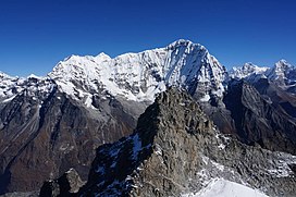 Kang Nachugo in 2016 | |
| Highest point | |
| Elevation | 6,735 m (22,096 ft)[1] |
| Prominence | 935 m (3,068 ft) |
| Coordinates | 27°54′18″N 86°26′33″E / 27.90500552217589°N 86.44248796855057°ECoordinates: 27°54′18″N 86°26′33″E / 27.90500552217589°N 86.44248796855057°E |
| Geography | |
 Kang Nachugo | |
| Country | Nepal |
| Province | Bagmati |
| District | Dolakha |


Kang Nachugo is a mountain located in Gaurishankar, Dolakha District, Nepal at an elevation of 6,735 metres (22,096 ft) above sea level.[1][2] It was first climbed in 2008 by Joe Puryear, and David Gottlieb.[3][4]
References[]
- ^ a b "The First Ascent of Kang Nachugo". Climbing. 14 November 2008. Archived from the original on 25 March 2021. Retrieved 25 March 2021.
- ^ "Takargo: Rolwaling's Hidden Gem". Alpinist. Archived from the original on 25 March 2021. Retrieved 25 March 2021.
- ^ "Kang Nachugo first ascent for Joe Puryear & David Gottlieb". PlanetMountain. Archived from the original on 25 March 2021. Retrieved 25 March 2021.
- ^ "AAC Publications - Kang Nachugo, South Face and West Ridge". American Alpine Club. Archived from the original on 25 March 2021. Retrieved 25 March 2021.
This article related to a mountain or hill in Nepal is a stub. You can help Wikipedia by . |
Categories:
- Mountains of the Bagmati Province
- Six-thousanders of the Himalayas
- Mountain ranges of the Himalayas
- Dolakha District
- Nepal mountain stubs