Kanzelwand
show This article may be expanded with text translated from the corresponding article in German. (June 2010) Click [show] for important translation instructions. |
This article does not cite any sources. (February 2016) |
| Kanzelwand (Warmatsgundkopf) | |
|---|---|
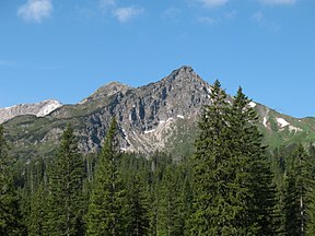 The Walser Hammerspitze (previously the Schüsser), the Kanzelwand and Zweiländerbahn | |
| Highest point | |
| Elevation | 2,058 m (6,752 ft) |
| Prominence | 88 m ↓ Col with the Walser Hammerspitze |
| Isolation | 0.8 km → Walser Hammerspitze |
| Coordinates | 47°20′6″N 10°12′27″E / 47.33500°N 10.20750°ECoordinates: 47°20′6″N 10°12′27″E / 47.33500°N 10.20750°E |
| Geography | |
 Kanzelwand (Warmatsgundkopf) Location in Bavaria, Germany (on border with Vorarlberg, Austria) | |
| Location | Border of Bavaria, Germany/ Vorarlberg, Austria |
| Parent range | , Allgäu Alps |
| Geology | |
| Mountain type | Main dolomite |


Kanzelwand (formerly known as Warmatsgundkopf from the Bavarian side) is a mountain on the border between Vorarlberg, Austria and Bavaria, Germany.
| Authority control |
|
|---|
This Bavaria location article is a stub. You can help Wikipedia by . |
This Austrian location article is a stub. You can help Wikipedia by . |
Categories:
- Allgäu Alps
- Mountains of Bavaria
- Mountains of Vorarlberg
- Mountains of the Alps
- Bavaria geography stubs
- Austria geography stubs