Kara Dag Mountain
| Kara Dag | |
|---|---|
 | |
| Highest point | |
| Elevation | 577 m (1,893 ft) |
| Coordinates | Coordinates: 44°55′53″N 35°13′22″E / 44.9314°N 35.2228°E |
| Geography | |
 Kara Dag | |
| Country | |
| Parent range | Crimean Mountains |
| Geology | |
| Age of rock | 172.8 ± 4.5 Ma [1] |

The Kara Dag ("Black Mount") is a volcanic rock formation which rises to a height of 577 meters between the Crimean coastal town of Koktebel and the valley. It has been the site of a since the early 20th century. Some 2874 ha of coastline and 809 ha of coastal waters have been protected as the Karadag Nature Reserve since 1979. The littoral is rich in picturesque cliffs such as the Devil's Gate. The best views of the Black Mount are from Koktebel and .
Gallery[]
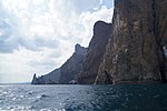
Karadag cliffs

Karadag coastline

Karadag cliffs by the sea

View from the top
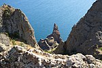
View from the top


See also[]
References[]
- ^ "Popov, D. V., Brovchenko, V. D., Nekrylov, N. A., et al.(2019). Removing a mask of alteration: Geochemistry and age of the Karadag volcanic sequence in SE Crimea. Lithos, 324, 371-384". doi:10.1016/j.lithos.2018.11.024. Cite journal requires
|journal=(help)
External links[]
- http://www.blacksea-crimea.com/Places/Kara-Dag.html
- https://web.archive.org/web/20070711091427/http://www.tourism.crimea.ua/eng/dostoprim/parks/reserves/kardagvr/index.html
- http://www.tour.crimea.com/ENGLISH/NAVIGATOR/ABOUT_CRIMEA/geography.shtml
| Mountains |  | |
|---|---|---|
| Passes | ||
| Landforms | ||
| Palaces | ||
| Fortresses | ||
| Ancient cities | ||
| Others | ||
This article about a location in Crimea is a stub. You can help Wikipedia by . |
Categories:
- Crimean Mountains
- Volcanoes of Ukraine
- Crimea geography stubs