Karanga (district)
Districts of Mangaia
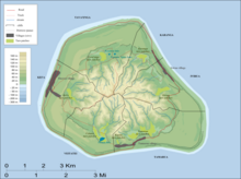
Karanga is the smallest of the six traditional districts of the island of Mangaia in the Cook Islands.[1] It is located in the northeast of the island, to the east of the District of Tava'enga and northwest of the District of Ivirua. The district was traditionally divided into 5 tapere:[1]
- Kaau-i-uta
- Kaau-i-miri
- Teia-pini
- Teia-poto
- Teia-roa
Mangaia Airport is located in this district.
References[]
- ^ a b Te Rangi Hiroa (1934). Mangaian Society. Honolulu: Bernice P. Bishop Museum. p. 126. Retrieved 9 August 2020 – via NZETC.
Coordinates: 21°54′22.83″S 157°54′11.15″W / 21.9063417°S 157.9030972°W

This Cook Islands location article is a stub. You can help Wikipedia by . |
Categories:
- Districts of the Cook Islands
- Mangaia
- Cook Islands geography stubs