Karekare, New Zealand

Karekare is a small coastal settlement in the Auckland Region of northern New Zealand, sandwiched between the Waitākere Ranges and a large black sand surf beach.
Location[]
It is located 35 kilometres (22 mi) west of Auckland city centre, south of the larger beach of Piha. It is north of Whatipu, south of Piha and west of the Centennial Memorial Park and Water Catchment area, which cover most of the native bushland Waitākere Ranges.
Pre-European history[]
Karekare, along with the greater Waitākere Ranges area, was traditionally settled by the Te Kawerau ā Maki iwi.[1][2] Karekare is one of the few locations where textiles created prior to European contact have been preserved.[3]
Tourism[]
Karekare is a popular destination for Aucklanders in summer, but receives fewer visitors than nearby Piha, partly because the road is narrow and only recently sealed. There are surf patrols in summer.
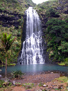
The track to the base of the Waitakere waterfall—Karekare falls—is a short walk from the road. The track to the top of the falls is now closed to help stop the spread of the incurable Kauri dieback disease.[4]

The settlement was immortalised in song by Crowded House on their Together Alone album in 1993, much of which was recorded at Karekare; the well known Dub/Reggae group, Salmonella Dub, used the name as well on their album Feel the Seasons Change - Live with the NZSO. The location will also be familiar to viewers of the film The Piano, which included beach scenes shot at Karekare and Piha.
Safety information[]
The rips along this section of coast are very unpredictable and can shift with little warning, and have caused a number of drownings. Lifeguards advise swimming between the red and yellow flags, during patrol hours.
Education[]
There is a small community primary school (Lone Kauri School) with approximately 30 students located at Karekare. It is an independently operating branch of Oratia School, under the supervision of a senior teacher.[5]
References[]
- ^ Lawrence, Joan (1990). "Combs from Rock Shelters in the Waitakere Ranges, West Auckland". Records of the Auckland Institute and Museum. 27: 61–71. ISSN 0067-0464.
- ^ "Te Kawerau ā Maki Deed of Settlement Schedule" (PDF). New Zealand Government. 22 February 2014. Retrieved 2021-01-29.
- ^ Mckendry, Lisa (2020). "Maori archaeological textiles: a structural analysis of Maori raranga 'woven' basketry from the Waitakere Ranges in Auckland Museum". Records of the Auckland Institute and Museum. 55: 19–28. doi:10.32912/ram.2020.55.2. ISSN 0067-0464. Retrieved 19 April 2021.
- ^ Council, Auckland. "Protect our kauri trees". Auckland Council. Retrieved 2018-09-04.
- ^ "Education Review Report: Oratia District School". Education Review Office. November 2008.
External links[]

| Wikimedia Commons has media related to Karekare. |
- Karekare website
- Karekare Surf LifeSaving Club
- Photographs of Karekare held in Auckland Libraries' heritage collections.
Coordinates: 36°59′10″S 174°28′46″E / 36.9861111111°S 174.479530556°E

- Tourist attractions in the Auckland Region
- Beaches of the Auckland Region
- Populated places in the Auckland Region
- Populated coastal places in New Zealand
- Waitākere Ranges