Karki, Azerbaijan
Karki
Kərki Տիգրանաշեն • Tigranashen | |
|---|---|
 | |
 Karki | |
| Coordinates: 39°47′08″N 44°56′37″E / 39.78556°N 44.94361°E | |
| Country | |
| District Province | Sadarak (de jure) Ararat (de facto) |
| Area | |
| • Total | 19 km2 (7 sq mi) |
| Population | |
| • Total | 741 |
| Time zone | UTC+4 (AZT) |


Karki (Azerbaijani: Kərki) is a village that is de jure an exclave of the Sadarak District of the Nakhchivan Autonomous Republic of Azerbaijan, de facto under the control of Armenia, administrated as part of its Ararat Province.[1] The village has been renamed Tigranashen (Armenian: Տիգրանաշեն) by the Armenian government after the ancient king Tigranes the Great, under whose reign the Kingdom of Armenia attained its greatest power.[1]
The village is located on the bank of the Akhuryan River near the Yerevan-Jermuk highway, which is 15 kilometres (9.3 mi) away from the district centre. The area of the village itself is 950 hectares (2,300 acres). The main highway connecting northern Armenia with southern Armenia passes right by the village, which is today mostly inhabited by Armenians, both locals and refugees from Azerbaijan.[2]
History[]
The village was captured on 19 January 1990, by Armenian forces during the First Nagorno-Karabakh War.[3][4][5][6]
Since May 1992, following the First Nagorno-Karabakh War, Karki has been controlled by Armenia, which administers the 19 km2 (7.3 sq mi) territory as part of its Ararat Province.[7]
After the war, many of the former inhabitants of Karki resettled in a new village, Yeni Kərki (New Karki), created within the Kangarli District of Azerbaijan.
Gallery[]
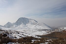
View of Karki from Armenia's main north-south highway.

See also[]
- Artsvashen
- Barkhudarli
- Yukhari Askipara
- Ashagi Askipara
- Yeni Kərki
References[]
- ^ a b Karki / Tigranashen exclave – Azerbaijan – Azerb.com
- ^ Brady Kiesling, Rediscovering Armenia, p. 30; original archived at Archive.org, and current version online on Armeniapedia.org.
- ^ ANAS, Azerbaijan National Academy of Sciences (2005). Nakhchivan Encyclopedia. Vol. I. Baku: ANAS. p. 294. ISBN 5-8066-1468-9.
- ^ "Nakhchivan Autonomous Republic". Archived from the original on 2012-12-09. Retrieved 2016-07-16.
- ^ Kərkinin taleyi
- ^ Sadarak District Court
- ^ [1] Archived November 19, 2008, at the Wayback Machine
Coordinates: 39°47.3′N 44°57.0′E / 39.7883°N 44.9500°E


This Nakhchivan Autonomous Republic location article is a stub. You can help Wikipedia by . |
- Populated places in Azerbaijan
- Populated places in Sadarak District
- Enclaves and exclaves
- Nakhchivan Autonomous Republic geography stubs