Kataja
Inakari | |
|---|---|
 | |
| Geography | |
| Location | Baltic Sea |
| Area | 0.71 km2 (0.27 sq mi) |
| Length | 2 km (1.2 mi) |
| Width | 0.35 km (0.217 mi) |
| Administration | |
| Region | Lapland |
| County | Norrbotten County |
| Demographics | |
| Population | 0 |
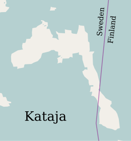
Kataja is an islet south of Haparanda in Norrbotten. It is the easternmost point of Sweden and it is part of the Haparanda archipelago. The islet has an area of 71 hectares (180 acres). It is about 2 kilometres (1.2 mi) long and 200 to 500 metres (660 to 1,640 ft) wide.
The name "Kataja" is Finnish for juniper. The island is divided between Sweden and Finland. The border was established in 1809 between two islands, a larger Swedish one called Kataja and a smaller Finnish one called Inakari. In the years since then post-glacial rebound has caused the land in the region to rise relative to sea level, joining the two islands. The border now crosses the southeastern part of the combined island, and is marked by two national cairns. Kataja's beaches are mostly boulders with some sand. The eastern peninsula is covered in deciduous trees such as rowan, alder and willow, while the remainder is covered by coniferous trees.[1]
See also[]
References[]
Citations
Sources
- "Kataja". bottenviken.se. Retrieved 2020-05-01.
Coordinates: 65°42′04″N 24°09′59″E / 65.70105°N 24.16630°E

- Extreme points of Sweden
- Swedish islands in the Baltic
- Finnish islands in the Baltic
- Uninhabited islands of Sweden
- Uninhabited islands of Finland
- Islands of Norrbotten County
- International islands
- Finland–Sweden border
- Landforms of Lapland (Finland)