Katiadi Upazila
Katiadi
কটিয়াদি | |
|---|---|
Upazila | |
 Katiadi Location in Bangladesh | |
| Coordinates: 24°15′00″N 90°47′30″E / 24.25000°N 90.79167°ECoordinates: 24°15′00″N 90°47′30″E / 24.25000°N 90.79167°E | |
| Country | |
| Division | Dhaka Division |
| District | Kishoreganj District |
| Area | |
| • Total | 219.22 km2 (84.64 sq mi) |
| Population (1991) | |
| • Total | 264,501 |
| • Density | 1,200/km2 (3,100/sq mi) |
| Time zone | UTC+6 (BST) |
| Postal code | 2330 |
| Website | katiadi |

Katiadi (Bengali: কটিয়াদি) is an upazila of Kishoreganj District in the Division of Dhaka, Bangladesh.[1]
Geography[]
Katiadi has an area of 219.22 square kilometres (84.64 sq mi).
Katiadi Upazila is the largest upazila of Kishoreganj district, with an area of 219.22 km2. It is bounded by Kishoreganj Sadar and Karimganj Upazilas on the north, Belabo and Monohardi upazilas on the south, Nikli and Bajitpur upazilas on the east, and Pakundia Upazila on the west. Purushbadhia, Doba and Reksa Beels are notable.
Demographics[]
As of the 1991 Bangladesh census, Katiadi had a population of 264,501, across 49,488 households. Males constituted 50.24% of the population and females 49.76%. The number of adults over the age of 18 is 125,001. Katiadi had an average literacy rate of 20.3% (7+ years), compared to the national average of 32.4%.[2]
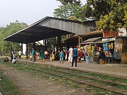
Street and railway[]
There have many Street in this upazila. Also have two railway station in Katidai
Administration[]
Katiadi thana became an upazila in 1983. Katiadi was declared a municipality in 1999.
| NO | Union Name |
|---|---|
| 01 | Banagram Union |
| 02 | |
| 03 | |
| 04 | |
| 05 | |
| 06 | |
| 07 | |
| 08 | |
| 09 |
The union parishads are subdivided into 97 mauzas and 156 villages.[3]
Kaitadi Municipality is subdivided into 9 wards and 20 mahallas.[3]
Mustak is the chairman of Katiadi Upazila.
See also[]
- Upazilas of Bangladesh
- Districts of Bangladesh
- Divisions of Bangladesh
References[]
- ^ Syed Md Saleh Uddin (2012), "Katiadi Upazila", in Sirajul Islam and Ahmed A. Jamal (ed.), Banglapedia: National Encyclopedia of Bangladesh (Second ed.), Asiatic Society of Bangladesh
- ^ "Population Census Wing, BBS". Archived from the original on 2005-03-27. Retrieved November 10, 2006.
- ^ a b "District Statistics 2011: Kishoreganj" (PDF). Bangladesh Bureau of Statistics. Archived from the original (PDF) on 13 November 2014. Retrieved 14 July 2014.
This Dhaka Division location article is a stub. You can help Wikipedia by . |
- Dhaka Division
- Kishoreganj District
- Dhaka Division geography stubs