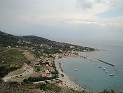
Kato Panta
The topic of this article may not meet Wikipedia's notability guideline for geographic features. (July 2018) |
Kato Panta
Κάτω Πάντα | |
|---|---|
Region of Othoni island | |
 Settlement of Ammos, Kato Panta, Othoni island, Greece | |
| Location | Othonoi, Greece |
| Settlements | List
|
| Time zone | UTC+2 (Eastern European Time) |
| • Summer (DST) | UTC+3 (Eastern European Summer Time) |
| ISO 3166 code | GRE |
Kato Panta (el: Κάτω Πάντα) is one of the two regions of Othoni island, near Corfu, Greece. It includes the central and eastern villages of the island (Ammos, Mastoratika, Kasimatika etc.) while Ano Panta (el: Άνω Πάντα) covers the western part of Othoni.[1]: 37 [2]
References[]
- ^ Ιόνιον άκρων, εκδόσεις. ΈΨΙΛΟΝ. 2000. ISBN 960-7062-99-X.
- ^ "Οθωνοί: Το νησί της Καλυψούς είναι το δυτικότερο σημείο της Ελλάδας (Photos + Video)". 6 December 2017.
Categories:
- Geography of Greece
- Ionian Islands geography stubs