Kattappana
Kattappana | |
|---|---|
Municipality | |
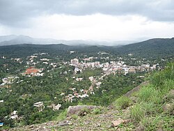 A distant view of Kattappana town | |
 Kattappana Location in Kerala, India | |
| Coordinates: 09°45′15″N 77°06′57″E / 9.75417°N 77.11583°ECoordinates: 09°45′15″N 77°06′57″E / 9.75417°N 77.11583°E | |
| Country | |
| State | Kerala |
| District | Idukki |
| Named for | Spices |
| Government | |
| • Type | Municipality |
| • Body | Kattappana Municipality |
| • Municipal Chairman | Joy Vettikuzhy |
| Area | |
| • Total | 52.77 km2 (20.37 sq mi) |
| Elevation | 1,000 - 1,100 m (−2,600 ft) |
| Population (2011)[1] | |
| • Total | 42,646 |
| • Density | 993/km2 (2,570/sq mi) |
| Languages | |
| • Official | Malayalam, English |
| Time zone | UTC+5:30 (IST) |
| PIN | 685508 (Head post office,Kattappana), 685515 (Kattappana south) |
| Telephone code | 04868 |
| Vehicle registration | KL-06 (Idukki) KL-37 (Vandiperiyar) KL-69 (Udumbanchola) |
| Nearest cities | Kottayam, Kochi, Madurai |
| Literacy | 92% |
| Lok Sabha constituency | Idukki |
| Sex ratio | 1016 ♂/♀ |
| Website | https://www.kattappana.org |


Kattappana is a municipal town in the Sahyadri (or Western Ghats) of Kerala state, India. It is the main urban centre in the high ranges of Idukki district, situated about 2,788.71–2,952.76 feet (850.00–900.00 m) above mean sea level, in the High Ranges, the high altitude region of Kerala has recently raised to the status of municipality. Kattappana is a class III urban centre. It is the first municipality in high range of Idukki district with the real mountainous touch of Idukki as Thodupuzha municipality is situated in low range. It is a major commercial town and flourished with the boost in production of agriculture and spices. Thopramkudy is the nearest town. Based on the 2011 Census, it had a total population of 42646, consisting of 21,159 males and 21,487 females.[1]
People migrated to this place mainly during 1950s from different parts of nearby townships like Pala, Kottayam etc. However, there were inhabitants even before 100 years. The main occupation is cultivation of commercial crops and spices like tea, coffee, pepper, cardamom, black pepper, and the majority of them are farmers.[2] One of the anchor institutions in Kattappana is . When it was started in 1968, it was one of the main hospitals in a 100-km radius. Managed by the Hospitaller Brothers of St. John of God, the hospital has grown to a tertiary level of 450 - bedded multi-speciality hospital with sixteen clinical disciplines. Even today, it is the only tertiary level referral center in this area.[3]
Municipal administration[]
Previously, Kattappana was included in the Udumbanchola tehsil (taluk) of Idukki district and was later included in the newly formed Idukki tehsil (taluk). In 1962, it became a grama panchayath and the first council was held under the presidentship of V.T Sebastian in 1964.[4] It was officially declared as municipality by the state government on 1 November 2015. It became the second municipality in the district, while Thodupuzha became the first one within the low ranges. The first municipal chairman was Mr. Johny Kulampallil and the current municipal chairperson is Ms Beena Joby. [5]
Demographics[]
It is one of the more important commercial centre in the high ranges and was on a fast track in terms of development and infrastructure building. Kattappana became a grama panchayat in 1962 and the first panchayat council under the presidency of V.T. Sebastian was formed in 1964.
However, it was the development of the Kottayam–Kattappana road and the Puliyanmala–Thodupuzha State highway that turned the town into a commercial centre. It was the agriculture sector that played a pivotal role in economically uplifting the town
As of 2011 census data, the population was 42,646, with 21,159 males and 21,487 females. The population in the age group 0–6 years are 4,412. The Scheduled Castes (SC) were 2,585 and the Scheduled Tribes (ST) were recorded as 524. The number of literates are 36,418 with the average literacy rate at 95.25%.[1]
The town had a large population of Syrian Catholic families who migrated to Kattappana in early 1950s from Central Travancore.[6] The migrations were majorly from Palai, Chenganassery and Kanjirapally taluks of Kottayam district and Pathanamthitta. Apart from the Catholics, the Nadar, Viswakarma, Nair, and Ezhava communities also make up a good part of the population. The landmark of the town is an edifice dedicated to Narayana Guru. There are also Muslim families and the Juma Masjid caters to their religious needs.
Descendants of earlier inhabitants, the tribals of the forest, can still be seen. The Mannan tribe is now concentrated around Kovilmala, near Kanchiyar.[7] Before large scale migration and settlement took place in Kattappana and surrounding areas in early 1950s, there were Tamil farmers. There is a sizable number of Tamil labor force forming part of the floating population of Kattappana.
Agriculture[]


Kattappana is the center for spices trade and the primary producer of cardamom[8] and black pepper. The main occupation of people of Kattappana is agriculture. A specific type Njallani high yielding variety of cardamom, was developed in Kattappana. It is also the centre of production and marketing of coffee, cocoa and ginger. There are also several reputed tea plantations (Tata Tea, A V Thomas & Co, Malayalam Plantations, Kannan Devan etc.) in adjoining areas of the district.
Spices Board (erstwhile Cardamom Board under Government of India) has an office in Kattappana. A Spices Park is established at Puttadi near Kattappana. Cardamom Research Institute is situated at Pampadumpara.[citation needed]
Njallani high yielding variety of cardamom was developed by Sebastian Joseph Njallani of Kattappana, who migrated to Kattappana in 1952.[9]
But still there are people who has not received pattayam for their land.
Climate[]
The climate of Kattappana falls under the Köppen climate classification. The place normally experiences a moderate climate. The humidity rises from the month of March to April and mid May. The average annual temperature here is 23 °C. The months of June, July, August and October receives significant amount of rainfall. November and December are the coldest months in the year.
Cartoonist Sajidas mohan (National award winner)
Joy Vettikuzhi (Chairman, Kattappana MunicipalityLate Bro. Forthunatus Thanhauser OH (Servant of God
Fr Francis Dominic OFM (Founder, Assisi Snehashram
Ambi Neenasam (Actor, Malayalam Cinema)
| hideClimate data for Kattappana, Kerala | |||||||||||||
|---|---|---|---|---|---|---|---|---|---|---|---|---|---|
| Month | Jan | Feb | Mar | Apr | May | Jun | Jul | Aug | Sep | Oct | Nov | Dec | Year |
| Average high °C (°F) | 26.1 (79.0) |
27.4 (81.3) |
29.1 (84.4) |
29.3 (84.7) |
29.2 (84.6) |
27.2 (81.0) |
26.1 (79.0) |
26.5 (79.7) |
26.8 (80.2) |
26.2 (79.2) |
25.5 (77.9) |
25.5 (77.9) |
27.1 (80.7) |
| Average low °C (°F) | 16.8 (62.2) |
17.5 (63.5) |
19.0 (66.2) |
20.2 (68.4) |
20.8 (69.4) |
20.1 (68.2) |
19.6 (67.3) |
19.6 (67.3) |
19.3 (66.7) |
19.1 (66.4) |
18.5 (65.3) |
17.2 (63.0) |
19.0 (66.2) |
| Average precipitation mm (inches) | 22 (0.9) |
30 (1.2) |
52 (2.0) |
116 (4.6) |
163 (6.4) |
307 (12.1) |
396 (15.6) |
246 (9.7) |
163 (6.4) |
252 (9.9) |
176 (6.9) |
75 (3.0) |
1,998 (78.7) |
| Source: Climate-Data.org[10] | |||||||||||||
References[]
- ^ Jump up to: a b c "Kattappana population". The Registrar General & Census Commissioner, India. Retrieved 30 June 2014.
- ^ "'Trial Run Begins at Spices Park'". The Hindu. 6 September 2010. Archived from the original on 10 September 2010. Retrieved 30 June 2014.
- ^ "St. John's Hospital website". Retrieved 17 August 2016.
- ^ "Kattappana to become a municipality - The Hindu › kerala › article7204111". The Hindu. 15 May 2015. Retrieved 6 December 2016.
- ^ "UDF wrests power in Kattappana and Thodupuzha - The Hindu› kerala › article7894574". The Hindu. 19 November 2015. Retrieved 7 December 2016.
- ^ "St George Forane Church, Kattappana". Archived from the original on 31 March 2012. Retrieved 9 October 2011.
- ^ Mannan tribe
- ^ Cardamom Cultivation
- ^ "Tale of an Indigenous Farmer", Rediff.com
- ^ "CLIMATE: KATTAPANA", Climate-Data.org. Web: [1].
External links[]
| Wikimedia Commons has media related to Kattappana. |

- Cities and towns in Idukki district