Kaukonahua River
This article needs attention from an expert in Hawaii or Rivers. The specific problem is: General expansion is needed considering that this is arguably the longest river in the Hawaiian Islands, but especially information on its discharge, watershed (including details on its source and mouth), navigability, and cultural significance is needed. |
| Kaukonahua River Kaukonahua Stream | |
|---|---|
 Location of mouth | |
| Location | |
| Country | United States |
| State | Hawaii |
| Region | Oahu |
| Physical characteristics | |
| Source | |
| • location | Oahu, Hawaii |
| • coordinates | 21°29′49″N 158°02′56″W / 21.4970382°N 158.0488229°W |
| Mouth | |
• location | , Pacific Ocean |
• coordinates | 21°34′47″N 158°7′10″W / 21.57972°N 158.11944°WCoordinates: 21°34′47″N 158°7′10″W / 21.57972°N 158.11944°W |
• elevation | Sea level |
| Length | ~ 53 km (33 mi) |


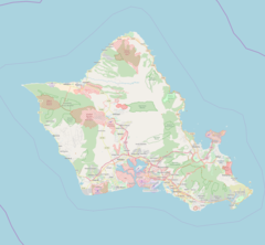
The Kaukonahua Stream[1] or Kaukonahua River is a 9.9-mile-long (15.9 km)[2] river on the island of Oʻahu which is one of the Hawaiian Islands. Including its longer South Fork, the stream's total length is 28.0 miles (45.1 km).[2] It flows down in a generally northwest direction, from 21°30′7″N 157°54′13″W / 21.50194°N 157.90361°W into the Pacific Ocean. The North and South forks meet at coordinates 21°29′44″N 158°5′50″W / 21.49556°N 158.09722°W.[1] It is the longest river of the whole island group. It empties into Kaiʻaka Bay near Waialua, Hawaii.
References[]
- ^ a b U.S. Geological Survey Geographic Names Information System: Kaukonahua Stream
- ^ a b U.S. Geological Survey. National Hydrography Dataset high-resolution flowline data. The National Map Archived 2012-04-05 at WebCite, accessed April 28, 2011
Categories:
- Rivers of Hawaii
- Bodies of water of Oahu
- Western United States river stubs
- Hawaii geography stubs