Kearns Peninsula

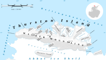
Map of Thurston Island.

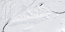
Satellite image of Thurston Island.
Kearns Peninsula (72°3′S 99°13′W / 72.050°S 99.217°WCoordinates: 72°3′S 99°13′W / 72.050°S 99.217°W) is a broad ice-covered peninsula between Potaka Inlet and Peale Inlet on the north side of Thurston Island, Antarctica. It was named by the Advisory Committee on Antarctic Names after Lieutenant , U.S. Navy Reserve, co-pilot of the Operation Highjump PBM Mariner seaplane that crashed on adjacent Noville Peninsula, December 30, 1946. Kearns and five other survivors were rescued on January 12, 1947.[1]
Maps[]
- Thurston Island – Jones Mountains. 1:500000 Antarctica Sketch Map. US Geological Survey, 1967.
- Antarctic Digital Database (ADD). Scale 1:250000 topographic map of Antarctica. Scientific Committee on Antarctic Research (SCAR). Since 1993, regularly upgraded and updated.
References[]
- ^ "Kearns Peninsula". Geographic Names Information System. United States Geological Survey. Retrieved 2013-04-16.
![]() This article incorporates public domain material from the United States Geological Survey document: "Kearns Peninsula". (content from the Geographic Names Information System)
This article incorporates public domain material from the United States Geological Survey document: "Kearns Peninsula". (content from the Geographic Names Information System)
Categories:
- Peninsulas of Ellsworth Land
- Thurston Island geography stubs
 WikiMiniAtlas