Kenai Lake
| Kenai Lake | |
|---|---|
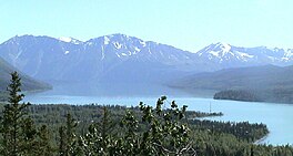 North Kenai lake near Cooper Landing | |
 Kenai Lake | |
| Location | Kenai Peninsula, Alaska |
| Coordinates | 60°23′32″N 149°34′24″W / 60.39222°N 149.57333°WCoordinates: 60°23′32″N 149°34′24″W / 60.39222°N 149.57333°W |
| Type | Natural Freshwater |
| Primary inflows | Snow River, Trail River |
| Primary outflows | Kenai River |
| Basin countries | United States |
| Max. length | 22 mi (35 km) |
| Surface area | 13,813 acres (5,590 ha) |
| Average depth | 299 ft (91 m) |
| Max. depth | 540 ft (160 m) |
| Surface elevation | 433 ft (132 m) |
| Settlements | Cooper Landing, Primrose |


Kenai Lake is a large, "zig-zag" shaped lake[1] on the Kenai Peninsula, Alaska. The lake forms the headwaters of the Kenai River,[2] and is itself a destination for fishing and other outdoor activity. Due to its size and shape it is accessible from both the Sterling Highway and the Seward Highway.
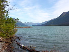
South end of Kenai Lake near Primrose
See also[]
References[]
External links[]
- Panoramic view of the lake from Cooper Landing
| show Kenai River system |
|---|

| show Authority control |
|---|
This article about a location in the Kenai Peninsula Borough, Alaska is a stub. You can help Wikipedia by . |
Categories:
- Lakes of Kenai Peninsula Borough, Alaska
- Lakes of Alaska
- Kenai Mountains-Turnagain Arm National Heritage Area
- Kenai Peninsula Borough, Alaska geography stubs