Keweenaw Fault
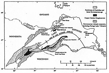
The Keweenaw Fault is a reverse fault that bisects the Keweenaw Peninsula of the Upper Peninsula of Michigan.[1] The fault is the boundary between the Midcontinent Rift System and adjacent Precambrian terrain. The peninsula, itself, is the southeastern side of a large syncline beneath Lake Superior. The northwestern side forms Isle Royale.[2]
The fault is more than 100 miles (160 kilometers) long and traces a northwesterly path.[3] The fault is most likely younger than the Jacobsville Formation and the Devonian Period.[4]
A seismic event in 1906 claimed to be an earthquake has been attributed to a rock burst, as the area has been significantly mined.[5]
The Natural Wall[]
One significant feature along the Keweenaw Fault is known as the Natural Wall. The Wall is a near-vertical slope of sandstone at a maximum inclination of 85°.[6]
References[]
- ^ Brandes, Paul. "Geology of the Keweenaw Peninsula, Michigan". mindat.org. Retrieved March 4, 2012.
- ^ Huber, N. King (1975). "The Geologic Story of Isle Royale National Park". United States Geological Survey. Retrieved February 2, 2008. Cite journal requires
|journal=(help) - ^ Hamblin, W.M. Kenneth (1958). The Cambrian Sandstones of Northern Michigan (PDF) (Report). State of Michigan Department of Conservation. p. 47. Retrieved February 16, 2012.
- ^ Hamblin, W.M. Kenneth (1958). The Cambrian Sandstones of Northern Michigan (PDF) (Report). State of Michigan Department of Conservation. p. 48. Retrieved February 16, 2012.
- ^ McLaren, Noël (August 30, 2011). "Could the Keweenaw Fault become active?". Upper Michigan's Source. Retrieved March 4, 2012.
- ^ Irving, E. D.; Chamberlin, T. C. (1885). "Observations on the Junction Between the Eastern Sandstone and the Keweenwaw Series on Kweweenaw Point, Lake Superior" (PDF). State of Michigan. Retrieved July 21, 2011.
This Michigan state location article is a stub. You can help Wikipedia by . |

- Michigan geography stubs
- Geology of Michigan