Kfeir
Kfeir
كفير | |
|---|---|
City | |
 Kfeir Location within Lebanon | |
| Coordinates: 33°25′46″N 35°44′26″E / 33.42944°N 35.74056°ECoordinates: 33°25′46″N 35°44′26″E / 33.42944°N 35.74056°E | |
| Country | |
| Governorate | Nabatieh Governorate |
| District | Hasbaya District |
| Elevation | 900 m (3,000 ft) |
| Time zone | UTC+2 (EET) |
| • Summer (DST) | UTC+3 (EEST) |
| Dialing code | +961 |

Kfeir (Arabic: الكفير) is a small village nestled 900 m above sea level, in Hasbaiya District (Qada'a), an administrative division of Nabatiyeh Governorate (Mohafazah) along the steep slopes of the top of the Jebel Sheikh in Lebanon.
The village enjoys mild summers of an average temperature of 25ºC. However, the winters are much colder and the village receives heavy snow. Kfeir's high altitude allows fog to form above the hills even in summer, giving the village a mystical and spiritual scenery.
The inhabitants of Kfeir are Christians and Druze, and they mainly cultivate olives, pines and other fruit trees.
Notable people[]
- Emily Nasrallah, Lebanese novelist
- Fares al-Khoury, Syrian politician
- Issam Abou Jamra, former Deputy Prime Minister of Lebanon
- , candidate for the 2018 Lebanese general election
- Assaf Abu Rahhal, Lebanese journalist killed in the 2010 Israel–Lebanon border clash
References[]
External links[]
- http://www.kfeir.com/
- Kfayr Ez Zait, Localiban
Capital: Hasbaya | ||
| Towns and villages | 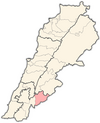 | |
| Other | ||
Categories:
- Populated places in Hasbaya District
- Populated places in Lebanon
- Maronite Christian communities in Lebanon
- Eastern Orthodox Christian communities in Lebanon