
Kharua Rajapur
Kharua Rajapur | |
|---|---|
Village | |
 | |
| Nickname(s): Rajapur | |
 Kharua Rajapur Location in West Bengal, India | |
| Coordinates: 22°59′41″N 88°45′13″E / 22.99479°N 88.753568°E | |
| Country | India |
| State | West Bengal |
| Division | Presidency division |
| District | North 24 Parganas district |
| Government Gram Panchayet | |
| • Panchayet Pradhan | Hema Biswas (TMC) |
| Area | |
| • Village | 2.33 km2 (0.90 sq mi) |
| • Rural | 233 ha (576 acres) |
| Dimensions | |
| • Length | 2.5 km (1.6 mi) |
| • Width | 1.3 km (0.8 mi) |
| Elevation | 9 m (30 ft) |
| Population (2011) | |
| • Village | 1,591 |
| • Density | 680/km2 (1,800/sq mi) |
| Time zone | UTC+5.30 (IST) |
| ISO 3166 code | IN-WB |

Kharua Rajapur is a village in Kalupur gram panchayat in Bangaon CD Block in Bangaon subdivision of North 24 Parganas district in the Indian state of West Bengal.
Geography[]
Kharua Rajapur is 15 kilometres (9.3 mi) from subdivision headquarters Bangaon and 52 kilometres (32 mi) from district headquarters Barasat. The nearest railway station is Chandpara railway station at Chandpara.[1]

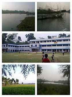
Choita river at Kharua Rajapur
Choita river flows past Kharua Rajapur.[2]
Demographics[]
In the 2011 census Kharua Rajapur had a population of 1591, of which 813 were males and 778 were females. Children age 0-6 number 151. The literacy rate is 89.93.[3]
Education[]

Maine building of Kharua Rajapur High School
One higher secondary school and two primary schools operate in Kharua Rajapur:
- G.R.F.P Primary School
- S.S.K.M Primary School
References[]
- ^ "Kharua Rajapur pin code".
- ^ "বিষমুক্ত জল দেবে কে,প্রশ্ন মানুষের". আনন্দবাজার প্রত্রিকা. Retrieved 8 April 2016.
- ^ "Kharua Rajapur Population -North Twenty Four Parganas,West Bengal,India".
- ^ "Kharua Rajapur High School-North Twenty Four Parganas,West Bengal".
Cities, towns, locations and neighbourhoods in North 24 Parganas district, Presidency division | |||||||||
|---|---|---|---|---|---|---|---|---|---|
| Municipal cities/ towns and Census towns |  Divisions of West Bengal | ||||||||
| Locations other than cities and towns |
| ||||||||
| Neighbourhoods of other cities and towns in the district | |||||||||
| Related topics |
| ||||||||
Categories:
- Villages in North 24 Parganas district