Kingswood, South Gloucestershire
| Kingswood | |
|---|---|
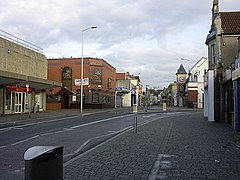 Regent Street, Kingswood | |
 Kingswood Location within Gloucestershire | |
| Population | 40,734 (2011 Census) |
| OS grid reference | ST649736 |
| Unitary authority | |
| Ceremonial county |
|
| Region | |
| Country | England |
| Sovereign state | United Kingdom |
| Post town | BRISTOL |
| Postcode district | BS15 |
| Dialling code | 0117 |
| Police | Avon and Somerset |
| Fire | Avon |
| Ambulance | South Western |
| UK Parliament | |

Kingswood is a suburban town in South Gloucestershire, England, bordering the eastern edge of the City of Bristol. The suburb is situated 3.4 miles (5.5 km) east-northeast of Bristol city centre and 102 miles (164 km) west of London.[1][2]
Broadly speaking, Kingswood covers the area from John Cabot Academy in the west to the A4174 ring road in the east. Some areas which are in close proximity to Kingswood, such as Two Mile Hill and St George East (both located within the City of Bristol) and parts of Hanham and Warmley Hill are often considered to be part of Kingswood by locals.
The border between South Gloucestershire and the City of Bristol is situated at the western end of Kingswood's High Street. Although anything beyond this point is no longer technically Kingswood, locals often consider the shops and residential areas that fringe the road named Two Mile Hill (located within the area of the same name) to be a continuation of Kingswood.
Royal Forest[]
In Saxon times, The 'King's Wood' was a royal hunting estate which surrounded Bristol, extending as far as Filwood in South Bristol. "From early days the Constable of Bristol Castle, the king's officer in the area, was also the Chief Ranger of the Kingswood Forest and the first of these recorded is Ella who died in 920. At the edge of the forest, to the north of the River Froom, lay the little hamlet of Stapleton, the name of which is Saxon in origin, being held to mean "The farm, homestead or croft - by or near the Stapol, post or pillar"".[3]
Demography[]
Kingswood and Staple Hill are the only areas that are unparished (an area that doesn't have an incorporated town council on its own) in South Gloucestershire. Furthermore, Kingswood is considered by ONS as part of Bristol, being within its urban subdivision.[4] This means that Kingswood isn't recognised as an individual settlement either statistically or administratively, being unparished and part of a larger urban subdivision, parliament constituency and district with all three divisions containing other areas. Hence its population is taken from four ward boundaries in South Gloucestershire. Kingswood is made up of three wards: Woodstock, New Cheltenham and Kingswood Wards[5] These wards had a combined population of 40,734 in 2011, with a largely white British population.[6]
Women in Kingswood had the fourth lowest life expectancy at birth, 74.3 years, of any ward in England and Wales in 2016.[7]
Transport[]
Kingswood High Street is around 3 miles (5 km) south of the M4 and 2.5 miles (4 km) east of Lawrence Hill railway station. Buses connect the town to surrounding areas including the City Centre, Southmead Hospital, Keynsham and Cribbs Causeway.
Coal mining[]

The Kingswood area first came into industrial prominence in the late 17th century, because of coal mining. Typical of these were coal fields in the Easton and Coalpit Heath/Yate areas.[8] The coal mining history still affects the town with gardens occasionally opening up. The local MP has petitioned in Parliament for full surveys of the coal mines under the town.[9] A recent archaeological excavation of the Wade Street area of Kingswood has uncovered artisans' houses that were established in the early 18th century. These dwellings were demolished as part of a slum clearance project in the mid 20th century.[10]
The Whit Walk[]
There is an annual procession held on the morning of the Whit Bank Holiday. Its origins are uncertain, but it appears to have taken place at least since 1939. The walk is the subject of an ethnographic study by the English anthropologist Timothy Jenkins.[11]
References[]
- ^ "Distance between Kingswood, Bristol, United Kingdom and London, United Kingdom (UK)". distancecalculator.globefeed.com.
- ^ "Distance between Bristol, United Kingdom and Kingswood, Bristol, United Kingdom (UK)". distancecalculator.globefeed.com.
- ^ Penny, John (2008). "Bristol Past". fishponds.org.uk. Fishponds Local History Society. Retrieved 20 October 2011.
- ^ "Bristol (Bristol, South West England, United Kingdom) - Population Statistics, Charts, Map, Location, Weather and Web Information". www.citypopulation.de.
- ^ http://www.andrewteale.me.uk/2007/maps/s-glos07.png
- ^ Services, Good Stuff IT. "South Gloucestershire - UK Census Data 2011". UK Census Data.
- ^ Bennett, James; et al. (22 November 2018). "Contributions of diseases and injuries to widening life expectancy inequalities in England from 2001 to 2016: a population-based analysis of vital registration data". Lancet public health. Archived from the original on 31 May 2019. Retrieved 23 November 2018.
- ^ http://www.cems.uwe.ac.uk/~rstephen/livingeaston/local_history/coalmining/Kingswood.html Archived 4 March 2016 at the Wayback Machine cems.uwe.ac.uk
- ^ "Former Mine Shafts (Kingswood) HC Deb 25 November 1996 vol 286 cc125-32". Hansard. Retrieved 3 May 2021.
- ^ Corcos, Nick (2017). "Excavations in 2014 at Wade Street, Bristol - a documentary and archaeological analysis". Internet Archaeology (45). doi:10.11141/ia.45.3.
- ^ Timothy Jenkins, Religion in English Everyday Life: An Ethnographic Approach, Oxford: Berghan Books, 1999
External links[]
| Wikimedia Commons has media related to Kingswood, South Gloucestershire. |
- Kingswood Rugby Club - The Official Home of Kingswood RFC
- Kingswood and Mangotsfield Archaeological Assessment Report 1997
- Photographic Record of Kingswoods Past
- Kingswood Ten Sing – Youth performing arts group
- Audio from a talk entitled The Kingswood Colliers & the Cock Rd. Gang by Steve Mills for Bristol Radical History Group
| show Authority control |
|---|
- Kingswood, South Gloucestershire
- Towns in Gloucestershire
- Areas of Bristol
- Unparished areas in Gloucestershire