Knittelfeld
Knittelfeld | |
|---|---|
 | |
 Coat of arms | |
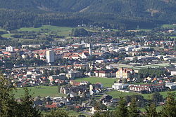
 Knittelfeld Location within Austria | |
| Coordinates: 47°12′54″N 14°49′46″E / 47.21500°N 14.82944°ECoordinates: 47°12′54″N 14°49′46″E / 47.21500°N 14.82944°E | |
| Country | Austria |
| State | Styria |
| District | Murtal |
| Government | |
| • Mayor | LAbg. Ing. Gerald Schmid(SPÖ) |
| Area | |
| • Total | 13.81 km2 (5.33 sq mi) |
| Elevation | 645 m (2,116 ft) |
| Population (2018-01-01)[2] | |
| • Total | 12,626 |
| • Density | 910/km2 (2,400/sq mi) |
| Time zone | UTC+1 (CET) |
| • Summer (DST) | UTC+2 (CEST) |
| Postal code | 8720 |
| Area code | 03512 |
| Vehicle registration | MT |
| Website | www.knittelfeld.at |

Knittelfeld is a city in Styria, Austria, located on the banks of the Mur river.
The name of the town has become notorious for the Knittelfeld Putsch of September 7, 2002, a party meeting of the Freedom Party of Austria, which resulted in the 2002 Austrian elections.
Notable residents[]
The following are past and present notable residents of Knittelfeld.
- Klaus Ambrosch (*1973), decathlete
- Gert Hofbauer (*1937), musician and conductor
- Marcel Ritzmaier (*1993), football player
- Stefan Rucker (*1980), cyclist
- Andi Siebenhofer (*1977), extreme sports athlete and entrepreneur
- Karl Troll (1923–1977), politician
- Lizzi Waldmüller (1904–1945), actress
- Zoran Lerchbacher (*1972), darts player
- Hermann Lichtenegger (1900-1984), resistance fighter, politician, Under Secretary of State
References[]
- ^ "Dauersiedlungsraum der Gemeinden Politischen Bezirke und Bundesländer - Gebietsstand 1.1.2018". Statistics Austria. Retrieved 10 March 2019.
- ^ "Einwohnerzahl 1.1.2018 nach Gemeinden mit Status, Gebietsstand 1.1.2018". Statistics Austria. Retrieved 9 March 2019.
External links[]
| show Authority control |
|---|
This Styria location article is a stub. You can help Wikipedia by . |
Categories:
- Cities and towns in Murtal District
- Styria geography stubs