Koczała
Koczała | |
|---|---|
Village | |
 Gmina Office in Koczała | |
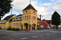
 Koczała | |
| Coordinates: 53°54′8″N 17°3′59″E / 53.90222°N 17.06639°E | |
| Country | |
| Voivodeship | Pomeranian |
| County | Człuchów |
| Gmina | Koczała |
| Population | 2,111 |
| Time zone | UTC+1 (CET) |
| • Summer (DST) | UTC+2 (CEST) |

Koczała [kɔˈt͡ʂawa] (German: Flötenstein) is a village in Człuchów County, Pomeranian Voivodeship, in northern Poland. It is the seat of the gmina (administrative district) called Gmina Koczała.[1] It lies approximately 35 kilometres (22 mi) north-west of Człuchów and 115 km (71 mi) south-west of the regional capital Gdańsk. It is located within the historic region of Pomerania.
The village has a population of 2,111.
Koczała was a royal village of the Polish Crown, administratively located in the Człuchów County in the Pomeranian Voivodeship.[2] During World War II the Germans operated a labor camp for prisoners of war from the Stalag II-B prisoner-of-war camp in the village.[3]
References[]
- ^ "Central Statistical Office (GUS) - TERYT (National Register of Territorial Land Apportionment Journal)" (in Polish). 2008-06-01.
- ^ Marian Biskup, Andrzej Tomczak, Mapy województwa pomorskiego w drugiej połowie XVI w., Toruń, 1955, p. 81 (in Polish)
- ^ "Les Kommandos". Stalag IIB Hammerstein, Czarne en Pologne (in French). Retrieved 25 April 2020.
Coordinates: 53°54′8″N 17°3′59″E / 53.90222°N 17.06639°E
This Człuchów County location article is a stub. You can help Wikipedia by . |
- Villages in Człuchów County
- Człuchów County geography stubs