Kohila Parish
Kohila Parish
Kohila vald | |
|---|---|
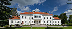 Kohila manor | |
 Flag  Coat of arms | |
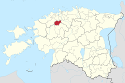 Kohila Parish within Rapla County. | |
| Country | |
| County | |
| Administrative centre | Kohila |
| Government | |
| • Mayor | Andrus Saare (Union of Pro Patria and Res Publica) |
| Area | |
| • Total | 230.20 km2 (88.88 sq mi) |
| Population (01.01.2009) | |
| • Total | 5,925 |
| • Density | 26/km2 (67/sq mi) |
| ISO 3166 code | EE-317 |
| Website | www.kohila.ee |
Kohila Parish (Estonian: Kohila vald) is the northernmost municipality of Rapla County, Estonia. It has a population of 5,925 (as of 1 January 2009) and an area of 230.20 km (143.04 mi).[1]
Settlements[]
- Borough
- Small boroughs
- Villages
Aandu - Adila - Angerja - Hageri - Kadaka - Lohu - Loone - Lümandu - Masti - Mälivere - Pahkla - Pihali - Pukamäe - Põikma - Rabivere - Rootsi - Salutaguse - Sutlema - Urge - Vana-Aespa - Vilivere
The administrative centre of Kohila Parish is Kohila borough (alev) with population 3,505 (as of 1 January 2006).[2] It is situated 33 km south to Estonia's capital, Tallinn and 22 km north to county's administrative center Rapla.
Local government[]
Current chairman of the council (volikogu esimees) is Margus Miller from the electoral coalition "Minu Kohila".[3]
Current mayor (vallavanem) is Andrus Saare[4] from the Union of Pro Patria and Res Publica.
Gallery[]
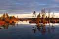
Lake Kaselaug in Rabivere nature reserve
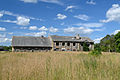
Ruins of Sutlema manor distillery

Tohisoo manor main building
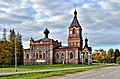
Kohila church

Hageri church

Ruins of Angerja vassal castle
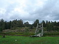
Lohu hill forts

Kohila paper factory

Pahkla glacial erratic


References[]
- ^ "Population figure and composition". [Statistics Estonia]. Retrieved 29 January 2010.
- ^ "Vallast" (in Estonian). [Kohila vald]. Archived from the original on 3 September 2009. Retrieved 29 January 2010.
- ^ "Vallavolikogu" (in Estonian). [Kohila vald]. Retrieved 29 January 2010.
- ^ "Vallavalitsus" (in Estonian). [Kohila vald]. Retrieved 29 January 2010.
External links[]
| Wikimedia Commons has media related to Kohila Parish. |
- Official website (in Estonian)
- Electoral coalition "Minu Kohila" (in Estonian)
Coordinates: 59°10′5″N 24°45′27″E / 59.16806°N 24.75750°E

| Rural municipalities | ||
|---|---|---|
This Estonia location article is a stub. You can help Wikipedia by . |
- Kohila Parish
- Estonia geography stubs