Kohukohu, New Zealand
Kohukohu | |
|---|---|
 Kohukohu Wharf | |
 Kohukohu | |
| Coordinates: 35°21′41″S 173°32′39″E / 35.36139°S 173.54417°E | |
| Country | New Zealand |
| Region | Northland Region |
| District | Far North District |

Kohukohu is a village on the Hokianga Harbour in the Northland Region of New Zealand. It was one of the first European settlements in New Zealand.
Kohukohu is situated on the northern shore of the harbour where it splits into two rivers, the Mangamuka River branching inland to the northeast and the Waihou River leading towards the east past Mangungu, Horeke and Rangiahua.
Where the harbour divides there is a small island called Motiti which was painted by Augustus Earle, the first European artist to spend several months in New Zealand, during his visit to the Hokianga in 1827. He wrote "we were sailing up a spacious sheet of water, which became considerably wider after entering it; while majestic hills rose on each side .... looking up the river we beheld various headlands stretching into the water and gradually contracting its width, 'till they became fainter and fainter in the distance and all was lost in the azure of the horizon".
Kohukohu is part of the Kohukohu-Broadwood statistical area. For demographics of this area, see Broadwood, New Zealand.
History and culture[]
Pre-European settlement[]
According to Te Tai Tokerau tradition, the legendary Polynesian explorer Kupe visited the area prior to his return voyage to Hawaiiki. Angry at the food from the hangi (earth oven) being insufficiently cooked, he swore at those responsible.[1] Kohukohu is Māori for a swearword or expletive.[2]

European settlement[]
The first recorded European to enter the Hokianga Harbour arrived in 1819 and by the 1830s, Kohukohu was the heart of New Zealand's timber industry.[3] The country's first Catholic mass was celebrated 8 kilometres north of Kohukohu at Totara Point in 1838.[4]
For nearly one hundred years Kohukohu was an important timber milling town and the largest commercial centre on the north of the harbour. In 1900, the township had a population of almost 2,000 people.[5]
Marae[]
Kohukohu has three marae affiliated with the hapū Te Ihutai: Pateoro or Te Karae Marae and Pōwhiri meeting house which affiliates with Te Rarawa;[6] Pikipāria Marae and Ngarunui meeting house which affiliates with Ngāpuhi;[7] and Tauteihiihi Marae and Tokimatahourua meeting house.[8]
There are also three marae affiliated with other Te Rarawa hapū: Motuti Marae and Tamatea meeting house are affiliated with Ngāti Tamatea, Ngāti Te Maara and Te Kai Tutae. Ngāi Tupoto Marae and Ngāhuia meeting house are affiliated with Ngāi Tūpoto and Ngāti Here. Waiparera Marae and Nukutawhiti meeting house are affiliated with Patutoka, Tahāwai, Te Whānau Pani and Te Hokokeha.[9][10]
In October 2020, the Government committed $1,407,731 from the Provincial Growth Fund to upgrade Ngāi Tupoto Marae and 8 other marae of Te Rarawa, creating 100 jobs.[11]
New Zealand's oldest bridge[]
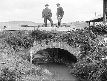
The Kohukohu footbridge near the centre of the town is the first stone bridge built in New Zealand, and is the oldest surviving bridge of any construction still in existence in the country.[12] It was built some time between 1843 and 1851 at the mouth of the Waihouuru Creek where it flowed into the Hokianga Harbour. At the time, ships from Sydney used sandstone blocks as ballast, which they left at Kohukohu in exchange for more-valuable timber, and these sandstone blocks were used to build the bridge. When a timber mill opened next to the bridge in 1879 sawdust was used to gradually reclaim the harbour, and the reclamation has buried most of the bridge, which is now about 100 m back from the foreshore. The bridge was registered in 2008 as a Category 1 Historic Place.[12]
- Kohukohu footbridge

Kohukohu c. 1867-1869. The old stone bridge is clearly visible, before the harbour was filled in
Kohukohu bridge around 1900 to 1920, with the timber mill visible in the background
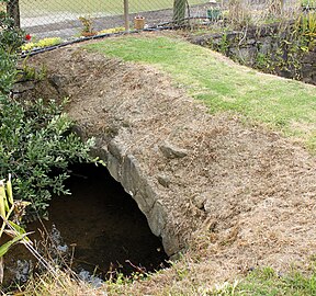
Kohukohu footbridge today


Kohukohu today[]

Today, Kohukohu is a community of 150 people who live within the village and approximately 350 who live in the surrounding area. The smaller settlements of Tauteihiihi, Motukaraka, Pikiparia, Te Karae, Mata, and Paponga are very close by. Kohukohu has a school, general store, café, art galleries, arts and crafts shop, hotel, voluntary fire and ambulance services, and a health clinic. There are also two churches and three marae within the locality.
In recent years,[when?] Kohukohu has become a destination for travellers who are attracted by its scenery, history, culture and arts.[13] There are a number of accommodation options available locally; including backpackers, cottages, and bed & breakfast facilities.[citation needed]
Education[]
Kohukohu School is a co-educational full primary (years 1-8) school[14] with a roll of 36 students as of March 2021.[15]
Notable people[]
- James Fisher-Harris, rugby league player for the Penrith Panthers
Notes[]
- ^ Te Ahukaramū Charles Royal (8 February 2005). "Places associated with Kupe". Te Ara Encyclopedia of New Zealand.
- ^ "kohukohu - Māori Dictionary". maoridictionary.co.nz. Retrieved 2020-08-09.
- ^ Shadbolt, Maurice (2010). Reader's Digest Guide to New Zealand. Reader's Digest.
A bawdy timber town from the 1830s
- ^ Shadbolt, Maurice (2010). Reader's Digest Guide to New Zealand. Reader's Digest.
New Zealand's first CAtholic mass was celebrated near by in 1838; a memorial 8 kilometres north on Totara Point marks the site.
- ^ Shadbolt, Maurice (2010). Reader's Digest Guide to New Zealand. Reader's Digest.
with a population of 20000 at the turn of the century, it now musters less than 200
- ^ "Pateoro (Te Karae) | Maori Maps". maorimaps.com. Retrieved 2020-08-09.
- ^ "Pikipāria | Maori Maps". maorimaps.com. Retrieved 2020-08-09.
- ^ "Tauteihiihi | Maori Maps". maorimaps.com. Retrieved 2020-08-09.
- ^ "Te Kāhui Māngai directory". tkm.govt.nz. Te Puni Kōkiri.
- ^ "Māori Maps". maorimaps.com. Te Potiki National Trust.
- ^ "Marae Announcements" (Excel). growregions.govt.nz. Provincial Growth Fund. 9 October 2020.
- ^ Jump up to: a b Park, Stuart (4 September 2007). "Stone Bridge". Heritage New Zealand. Retrieved 2 October 2018.
- ^ "Kohukohu Travel Guide". Jasons Travel Media.
- ^ Education Counts: Kohukohu School
- ^ "New Zealand Schools Directory". New Zealand Ministry of Education. Retrieved 27 April 2021.
External links[]
- Kohukohu community website
- Kohukohu School school website
- Village Arts website
Coordinates: 35°21′S 173°32′E / 35.350°S 173.533°E
| Wikimedia Commons has media related to Kohukohu. |
| hide Authority control | |
|---|---|
| General |
|
| National libraries | |
- Hokianga
- Populated places in the Northland Region