Kolhorn
Kolhorn | |
|---|---|
Village | |
 | |
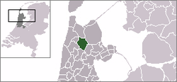 | |
 The town centre (dark green) and the statistical district (light green) of Kolhorn in the former municipality of Niedorp. | |
| Coordinates: 52°47′34″N 4°53′20″E / 52.79278°N 4.88889°ECoordinates: 52°47′34″N 4°53′20″E / 52.79278°N 4.88889°E | |
| Country | Netherlands |
| Province | North Holland |
| Municipality | Hollands Kroon |
| Population (2001) | |
| • Total | 645 |
| Time zone | UTC+1 (CET) |
| • Summer (DST) | UTC+2 (CEST) |

Kolhorn (West Frisian: Klòrre(n)) is a village in the Dutch province of North Holland. It is a part of the municipality of Hollands Kroon, and lies about 8 kilometres (5.0 mi) east of Schagen.
In 2001, the town of Kolhorn had 645 inhabitants. The built-up area of the town was 0.20 km², and contained 265 residences.[1] The statistical area "Kolhorn", which also can include the peripheral parts of the village, as well as the surrounding countryside, has a population of around 890.[2]

View of Kolhorn from Westfriese dike.

Marina of Kolhorn

Inner harbour
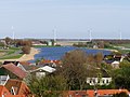
Kolhornerdiep, east of Kolhorn.

Laurens church of 1645

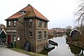
The "Oude Streek" in Kolhorn with the so called "School bridge"
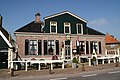
Restaurant "De Roode Leeuw"
Pump Station "Schager Kogge"


References[]
- ^ Statistics Netherlands (CBS), Bevolkingskernen in Nederland 2001. (Statistics are for the continuous built-up area).
- ^ Statistics Netherlands (CBS), Statline: Kerncijfers wijken en buurten 2003-2005 Archived 2006-07-24 at WebCite. As of 1 January 2005.
External links[]
| Wikimedia Commons has media related to Kolhorn. |
This North Holland location article is a stub. You can help Wikipedia by . |
- Populated places in North Holland
- Hollands Kroon
- North Holland geography stubs