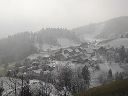
Koreno nad Horjulom
Koreno nad Horjulom | |
|---|---|
 | |
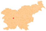
 Koreno nad Horjulom Location in Slovenia | |
| Coordinates: 46°1′58.06″N 14°17′18.42″E / 46.0327944°N 14.2884500°ECoordinates: 46°1′58.06″N 14°17′18.42″E / 46.0327944°N 14.2884500°E | |
| Country | |
| Traditional region | Inner Carniola |
| Statistical region | Central Slovenia |
| Municipality | Horjul |
| Area | |
| • Total | 4.41 km2 (1.70 sq mi) |
| Elevation | 662.3 m (2,172.9 ft) |
| Population (2002) | |
| • Total | 110 |
| [1] | |

Koreno nad Horjulom (pronounced [kɔˈɾeːnɔ nat xɔˈrjúːlɔm])[tone?] is a settlement in the hills north of Horjul in the Inner Carniola region of Slovenia.[2]
Name[]
The name of the settlement was changed from Koreno to Koreno nad Horjulom in 1953.[3]
Church[]

Sts. Hermagoras and Fortunatus Church
The local church in the settlement is dedicated to Saints Hermagoras and Fortunatus and belongs to the Parish of Horjul.[4]
References[]
- ^ Statistical Office of the Republic of Slovenia
- ^ Horjul municipal site
- ^ Spremembe naselij 1948–95. 1996. Database. Ljubljana: Geografski inštitut ZRC SAZU, DZS.
- ^ Družina RC in Slovenia journal site
External links[]
| Settlements | Administrative seat: Horjul
|  |
|---|---|---|
| Landmarks | ||
| Notable people | ||
This article about the Municipality of Horjul in Slovenia is a stub. You can help Wikipedia by . |
Categories:
- Populated places in the Municipality of Horjul
- Osrednjeslovenska statistical region geography stubs