Kota Marudu District
Kota Marudu District
Daerah Kota Marudu | |
|---|---|
District | |
 Seal | |
 | |
| Coordinates: 6°29′23″N 116°44′10″E / 6.48972°N 116.73611°ECoordinates: 6°29′23″N 116°44′10″E / 6.48972°N 116.73611°E | |
| Country | |
| State | |
| Division | Kudat |
| Capital | Kota Marudu |
| Government | |
| • District Officer | Lovita Koisun |
| Area | |
| • Total | 1,917 km2 (740 sq mi) |
| Population (2010) | |
| • Total | 66,374 |
| Website | www www |


The Kota Marudu District (Malay: Daerah Kota Marudu) is an administrative district in the Malaysian state of Sabah, part of the Kudat Division which includes the districts of Kota Marudu, Kudat and Pitas. The capital of the district is in Kota Marudu Town.
Etymology[]
Kota means Fort. The name Marudu originated from the language of Balangigi people from the words of "Mairudu" or "Maiuludu" which means "a position located in the same place", referring to the geographical position of Marudu Bay which forms a large bay. Since then, the term Mairudu turns to Marudu and Mailudu becomes Maludu. Hence, Western writers often refer to Marudu as Marudu, Marudo or Maludu. The name Marudu was first mapped by a Dutch sailor in 1595 who sailed from Brunei and reached Marudu, Palawan and the Sulu Archipelago. While in the waters of Marudu, he found the Balangigi people or also called by the Spaniards as the "Camucones"[note 1] became the sea troops of the Sultanates of Brunei and Sulu at the time.[2]
History[]
The district is once known as the stronghold of a local leader named Sharif Usman. The Sharif administer the area under the consent of the Sultanate of Sulu although he administer the place under his own as an independent chiefdom.[2] He later involved in a dispute with the colonial authorities of British North Borneo after being accused as a pirate and involved in a slave trade, where he was killed during a battle with the latter and his entire fort in the area was destroyed.[3]
Demographics[]
The population of Kota Marudu district according to the last census in 2010 is 66,374.[4] It consists mainly of Dusun, Rungus, Bajau, Orang Sungai and Chinese (mainly Hakkas and Hokkien). As in other districts of Sabah, there are a significant number of illegal immigrants from the nearby southern Philippines, notably from the Sulu Archipelago and Mindanao which are not included in the population statistics.
Gallery[]
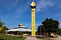
Tandek Mosque.

Kota Marudu Basel Church.

St. Theresa Catholic Church.

Goshen Seventh Day Adventist Church.


See also[]
- Districts of Malaysia
Notes[]
References[]
- ^ William Larousse (2001). A Local Church Living for Dialogue: Muslim-Christian Relations in Mindanao-Sulu, Philippines : 1965-2000. Gregorian Biblical BookShop. pp. 75–. ISBN 978-88-7652-879-8.
- ^ a b "Latar Belakang Daerah" (in Malay). Kota Marudu District Office. Archived from the original on 7 November 2017. Retrieved 7 November 2017.
- ^ Graham Saunders (5 November 2013). A History of Brunei. Routledge. pp. 76–. ISBN 978-1-136-87394-2.
- ^ "Population by ethnic group, Local Authority area and state, Malaysia" (PDF). Department of Statistics, Malaysia. 2010. Archived from the original (PDF) on 27 February 2012. Retrieved 5 November 2017.
Further reading[]
- Treacher, W. H (1891). "British Borneo: sketches of Brunai, Sarawak, Labuan, and North Borneo". University of California Libraries. Singapore, Govt. print. dept. p. 190.
- Rutter, Owen (1922). "British North Borneo - An Account of its History, Resources and Native Tribes". Cornell University Libraries. Constable & Company Ltd, London. p. 157.
- Tregonning, K. G. (1965). A History Of Modern Sabah (North Borneo 1881–1963). University of Malaya Press.
External links[]
![]() Media related to Kota Marudu District at Wikimedia Commons
Media related to Kota Marudu District at Wikimedia Commons
- (in Malay) Kota Marudu District Council
- (in Malay) Kota Marudu District Office
State of Sabah | |||||||||||||
|---|---|---|---|---|---|---|---|---|---|---|---|---|---|
Capital: Kota Kinabalu | |||||||||||||
| |||||||||||||
| Society |
| ||||||||||||
| Administrative divisions |
| ||||||||||||
| |||||||||||||
This Sabah location article is a stub. You can help Wikipedia by . |
- Districts of Sabah
- Sabah geography stubs