Kotoriba
Kotoriba | |
|---|---|
Municipality | |
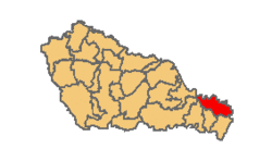 Location within Međimurje County | |
 Kotoriba Location of Kotoriba in Croatia | |
| Coordinates: 46°22′N 16°49′E / 46.367°N 16.817°E | |
| Country | |
| County | Međimurje |
| Government | |
| • Municipal mayor | Ljubomir Grgec (SDP) |
| Area | |
| • Total | 26.58 km2 (10.26 sq mi) |
| Population (2011)[1] | |
| • Total | 3,224 |
| • Density | 120/km2 (310/sq mi) |
| Time zone | UTC+1 (CET) |
| • Summer (DST) | UTC+2 (CEST) |
| Postal code | 40329 Kotoriba |
| Website | www |

Kotoriba (Hungarian: Kotor, earlier Kottori) is a village and municipality in Međimurje County, in northern Croatia.
It is located in the southeastern part of the county, near the Mura River and border with Hungary, approximately 36 kilometres southeast of Čakovec and 20 kilometres east of Prelog, the largest and second-largest cities of Međimurje County, respectively. It is connected with Čakovec by both road and railroad.
Kotoriba is the only village in the municipality. In the 2011 census, it had a population of 3,224.
Kotoriba is known for being the site of the oldest railway station in present-day Croatia. The opening ceremony was held on 24 April 1860.[2]
References[]
- ^ "Population by Age and Sex, by Settlements, 2011 Census: Kotoriba". Census of Population, Households and Dwellings 2011. Zagreb: Croatian Bureau of Statistics. December 2012.
- ^ http://www.kotoriba.hr/prvapruga.html Archived 2009-04-09 at the Wayback Machine (in Croatian)
External links[]
- Website of the municipality (in Croatian)
| show Subdivisions of Međimurje County |
|---|

Coordinates: 46°21′N 16°49′E / 46.350°N 16.817°E
| show Authority control |
|---|
This Međimurje County geography article is a stub. You can help Wikipedia by . |
- Municipalities of Croatia
- Populated places in Međimurje County
- Međimurje County geography stubs