Koudekerk aan den Rijn
Koudekerk aan den Rijn | |
|---|---|
Town | |
 | |
 Flag  Coat of arms | |
 | |
 The village (red) and the statistical district (light green) of Koudekerk aan den Rijn in the former municipality of Rijnwoude. | |
| Coordinates: 52°8′5″N 4°36′7″E / 52.13472°N 4.60194°ECoordinates: 52°8′5″N 4°36′7″E / 52.13472°N 4.60194°E | |
| Country | Netherlands |
| Province | |
| Municipality | Alphen aan den Rijn |
| Population (2007) | |
| • Total | 4,257 |
| Time zone | UTC+1 (CET) |
| • Summer (DST) | UTC+2 (CEST) |

Koudekerk aan den Rijn (English: Cold Church upon Rhine) is a town located in the municipality of Alphen aan den Rijn, Netherlands. It is located about 4 km west of the urban centre, in the province of South Holland.
The village Koudekerk aan den Rijn has a population of around 3730.[1] The statistical area "Koudekerk aan den Rijn", which also can include the surrounding countryside, has a population of around 4280.[1]
Koudekerk aan den Rijn was a separate municipality until 1991, when it became part of Rijnwoude. Until 1938, the municipality was known as Koudekerk.[2]

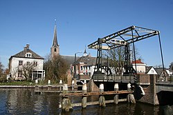
Reformed church, 19th century
Notable people[]
- Armin van Buuren, DJ, born in Leiden and grew up in Koudekerk aan den Rijn.
References[]
- ^ Jump up to: a b Statistics Netherlands (CBS), "Archived copy". Archived from the original on July 24, 2006. Retrieved July 24, 2006.CS1 maint: archived copy as title (link) Statline: Kerncijfers wijken en buurten 2003-2005. As of 1 January 2005.
- ^ Ad van der Meer and Onno Boonstra, "Repertorium van Nederlandse gemeenten", KNAW, 2006. "Archived copy". Archived from the original on February 20, 2007. Retrieved December 3, 2009.CS1 maint: archived copy as title (link)
External links[]
- J. Kuyper, Gemeente Atlas van Nederland, 1865-1870, "Koudekerk". Map of the former municipality in 1868.
| hide Authority control | |
|---|---|
| General |
|
| National libraries | |
This South Holland location article is a stub. You can help Wikipedia by . |
Categories:
- Populated places in South Holland
- Former municipalities of South Holland
- Alphen aan den Rijn
- South Holland geography stubs