Kouvaras
Kouvaras
Κουβαράς | |
|---|---|
 Kouvaras Location within the regional unit 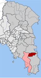 | |
| Coordinates: 37°50′N 23°58′E / 37.833°N 23.967°ECoordinates: 37°50′N 23°58′E / 37.833°N 23.967°E | |
| Country | Greece |
| Administrative region | Attica |
| Regional unit | East Attica |
| Municipality | Saronikos |
| • Municipal unit | 24.371 km2 (9.410 sq mi) |
| Elevation | 209 m (686 ft) |
| Population (2011)[1] | |
| • Municipal unit | 2,008 |
| • Municipal unit density | 82/km2 (210/sq mi) |
| Time zone | UTC+2 (EET) |
| • Summer (DST) | UTC+3 (EEST) |
| Postal code | 190 03 |
| Area code(s) | 22910 |
| Vehicle registration | Z |
| Website | www.koinotita-kouvara.gr |


Kouvaras (Greek: Κουβαράς) is a village and a former community in East Attica, Greece. Since the 2011 local government reform it is part of the municipality Saronikos, of which it is a municipal unit.[2] The municipal unit has an area of 24.371 km2.[3]
Geography[]
Kouvaras is situated in the southeastern part of the Attica peninsula. There are several low mountains around Kouvaras, including to its southwest and to its north. It is 2 km north of Keratea, 4 km southeast of Kalyvia Thorikou and 27 km southeast of Athens city centre. The Greek National Road 89 (Gerakas - Koropi - Lavrio - Sounio) passes southwest of the town. The municipal unit Kouvaras also includes the village Neos Kouvaras (pop. 566), 1 km to the southwest and the villages of Hagia Katerina and Fussa.
Historical population[]
| Year | Village population | Municipal unit population |
|---|---|---|
| 1981 | 1,194 | - |
| 1991 | 928 | 1,369 |
| 2001 | 1,091 | 1,542 |
| 2011 | 1,426 | 2,008 |
Historical monuments[]
The church of St. George. A wall painting monument (1743) of Georgios Markou the Argus, the great and prolific post-Byzantine ecclesiastic iconographer of the 18th century[4] (".... San Giorgio (agiografia su gli anni 1743), che si trova al paesino di Cuvara, dell 'Attica...." Evangelos Andreou http://ketlib.lib.unipi.gr/xmlui/handle/ket/849
References[]
- ^ a b "Απογραφή Πληθυσμού - Κατοικιών 2011. ΜΟΝΙΜΟΣ Πληθυσμός" (in Greek). Hellenic Statistical Authority.
- ^ "ΦΕΚ B 1292/2010, Kallikratis reform municipalities" (in Greek). Government Gazette.
- ^ "Population & housing census 2001 (incl. area and average elevation)" (PDF) (in Greek). National Statistical Service of Greece. Archived from the original (PDF) on 2015-09-21.
- ^ ".:BiblioNet : Γεώργιος Μάρκου ο Αργείος / Ανδρέου, Ευάγγελος". www.biblionet.gr. Retrieved 2018-11-16.
External links[]
- Official website (in Greek)
- GTP Travel Pages (community)
- News
Places adjacent to Kouvaras | ||||||||||||||||
|---|---|---|---|---|---|---|---|---|---|---|---|---|---|---|---|---|
| ||||||||||||||||
- Populated places in East Attica