Krasang District
Krasang
กระสัง | |
|---|---|
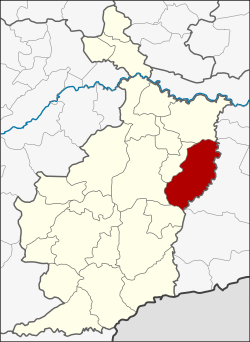 District location in Buriram Province | |
| Coordinates: 14°55′18″N 103°18′6″E / 14.92167°N 103.30167°ECoordinates: 14°55′18″N 103°18′6″E / 14.92167°N 103.30167°E | |
| Country | Thailand |
| Province | Buriram |
| Seat | Krasang |
| Area | |
| • Total | 652.700 km2 (252.009 sq mi) |
| Population (2005) | |
| • Total | 103,043 |
| • Density | 157.9/km2 (409/sq mi) |
| Time zone | UTC+7 (ICT) |
| Postal code | 31160 |
| Geocode | 3103 |

Krasang (Thai: กระสัง, pronounced [krā.sǎŋ]) is a district (amphoe) in the eastern part of Buriram Province, northeastern Thailand.
Geography[]
Neighboring districts are (from the south clockwise) Phlapphla Chai, Mueang Buriram, Huai Rat, Satuek of Buriram Province and Mueang Surin of Surin Province.
History[]
Originally part of tambon Song Chan of Mueang Buriram District, Krasang was made a tambon in 1937. On 26 April 1952 the three tambons Krasang, Song Chang, and Lamduan were placed together to form the minor district (king amphoe) Krasang.[1] It was upgraded to a full district on 23 July 1958.[2]
Administration[]
The district is divided into 11 sub-districts (tambons), which are further subdivided into 167 villages (mubans). Krasang is a township (thesaban tambon) which covers parts of tambon Krasang. There are a further 11 tambon administrative organizations (TAO).
| No. | Name | Thai name | Villages | Pop. | |
|---|---|---|---|---|---|
| 1. | กระสัง | 21 | 15,150 | ||
| 2. | ลำดวน | 18 | 11,372 | ||
| 3. | สองชั้น | 17 | 11,929 | ||
| 4. | Sung Noen | สูงเนิน | 19 | 10,473 | |
| 5. | หนองเต็ง | 18 | 11,871 | ||
| 6. | เมืองไผ่ | 13 | 7,103 | ||
| 7. | ชุมแสง | 12 | 6,538 | ||
| 8. | บ้านปรือ | 15 | 8,674 | ||
| 9. | ห้วยสำราญ | 14 | 6,992 | ||
| 10. | กันทรารมย์ | 12 | 8,467 | ||
| 11. | ศรีภูมิ | 8 | 4,474 |
References[]
- ^ ประกาศกระทรวงมหาดไทย เรื่อง ยกฐานะตำบลขึ้นเป็นกิ่งอำเภอ (PDF). Royal Gazette (in Thai). 71 (35 ง): 1314. June 1, 1958.
- ^ พระราชกฤษฎีกาจัดตั้งอำเภอกระสัง ... (PDF). Royal Gazette (in Thai). 75 (55 ก): 321–327. July 22, 1958.
External links[]
This Buriram Province location article is a stub. You can help Wikipedia by . |
- Amphoe of Buriram Province
- Isan geography stubs