Krems (Upper Austria)
| Krems | |
|---|---|
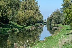 The Krems near Ansfelden | |
 | |
| Location | |
| Country | Austria |
| State | Upper Austria |
| Physical characteristics | |
| Mouth | |
• location | Traun |
• coordinates | 48°14′29″N 14°18′57″E / 48.2413°N 14.3159°ECoordinates: 48°14′29″N 14°18′57″E / 48.2413°N 14.3159°E |
| Length | 62.4 km (38.8 mi) [1] |
| Basin features | |
| Progression | Traun→ Danube→ Black Sea |

The Krems is an approximately 62-kilometre-long (39 mi) tributary of the Traun in Upper Austria.
It originates at the foot of the mountain in Micheldorf, runs northwards in the Traunviertel through the Upper Austrian Prealps, and flows into the Traun in , a district of Linz.
The largest towns in the valley of the Krems are Kirchdorf an der Krems, Schlierbach, Wartberg an der Krems, Kremsmünster, Rohr im Kremstal, Kematen an der Krems, Neuhofen an der Krems and Ansfelden.
References[]
- ^ DORIS Atlas (Upper Austria)
External links[]
 Media related to Krems (Traun) at Wikimedia Commons
This Upper Austria location article is a stub. You can help Wikipedia by . |
Categories:
- Tributaries of the Traun
- Rivers of Upper Austria
- Rivers of Austria
- Austria river stubs
- Upper Austria geography stubs