Kresta Bay
| Kresta Bay | |
|---|---|
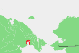
 Kresta Bay Location of Kresta Bay in Chukotka | |
 | |
| Location | Far North |
| Coordinates | 66°00′00″N 179°15′00″W / 66.000°N 179.250°WCoordinates: 66°00′00″N 179°15′00″W / 66.000°N 179.250°W |
| Native name | Залив Креста (Russian) |
| River sources | |
| Ocean/sea sources | Gulf of Anadyr |
| Basin countries | Russia |
| Max. length | 102 km (63 mi) |
| Max. width | 43 km (27 mi) |
| Average depth | 70 m (230 ft) |
| Settlements | Egvekinot |
Kresta Bay or Kresta Gulf (Russian: Залив Креста; Zaliv Kresta) is a large bay of the Gulf of Anadyr on the southern coast of the Chukotka Peninsula, Russian Federation. Administratively the bay is part of the Iultinsky District of Chukotka.
Geography[]
The Kresta Bay is open towards the south; it is almost 100 km in length and has an average width of about 43 km.[1] There are two inlets and a coastal lagoon enclosed by a landspit inside the bay.[2]
Kresta Bay is now a tourist destination. , served by Chukotavia, is located by Egvekinot, a small harbor in the bay.[3]
 An old U.S. Navy map showing Kresta Bay on its upper right corner. |
 View of Kresta Bay. |
History[]
This bay was first surveyed by Russian mariner Count Fyodor Petrovich Litke in 1828.
References[]
- ^ Zaliv Kresta - article from the Great Soviet Encyclopedia
- ^ "Zaliv Kresta". Mapcarta. Retrieved 8 April 2016.
- ^ Tourism Archived 2011-07-08 at the Wayback Machine
External links[]
Categories:
- Bays of Chukotka Autonomous Okrug
- Bays of the Bering Sea
- Chukotka Autonomous Okrug geography stubs
