Krogaspe
Krogaspe | |
|---|---|
 Coat of arms | |
show Location of Krogaspe within Rendsburg-Eckernförde district | |
 Krogaspe | |
| Coordinates: 54°7′N 9°55′E / 54.117°N 9.917°ECoordinates: 54°7′N 9°55′E / 54.117°N 9.917°E | |
| Country | Germany |
| State | Schleswig-Holstein |
| District | Rendsburg-Eckernförde |
| Municipal assoc. | Nortorfer Land |
| Government | |
| • Mayor | Nils Höfer |
| Area | |
| • Total | 11.82 km2 (4.56 sq mi) |
| Elevation | 27 m (89 ft) |
| Population (2020-12-31)[1] | |
| • Total | 429 |
| • Density | 36/km2 (94/sq mi) |
| Time zone | UTC+01:00 (CET) |
| • Summer (DST) | UTC+02:00 (CEST) |
| Postal codes | 24644 |
| Dialling codes | 04392 |
| Vehicle registration | RD |
| Website | www.amt-nortorfer- land.de |
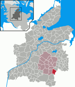


Krogaspe is a municipality in the district of Rendsburg-Eckernförde, in Schleswig-Holstein, Germany. Krogaspe is located north west of Neumünster close to Autobahn A7 and county highway 205 to Rendsburg.
History[]
Krogaspe was first mentioned in 1200 AD. The meaning of name is remote corner village with aspen. It is an indication that Krogaspe was a medieval settlement surrounded by poplar aspen.
The municipality is located on the historic military and trade route Ossenweg. Thousands of cattle have been driven down this old path through Schleswig-Holstein south towards the river Elbe.
In 1979, retired farmer Hinrich Plambeck released a chronicle of Krogaspe.
Politics[]
The municipal council is made up of 5 seats for the voter coop ADW and 4 seats for the voter coop KWG.
Coat of Arms[]
blazon: „Three green Espen trees next to each other above the red colored gable end of a lower-saxon timber frame farm house on a silver background"
References[]
| show Towns and municipalities in Rendsburg-Eckernförde |
|---|
| Authority control |
|---|
This Rendsburg-Eckernförde location article is a stub. You can help Wikipedia by . |
- Municipalities in Schleswig-Holstein
- Rendsburg-Eckernförde
- Rendsburg-Eckernförde geography stubs