Ku-ring-gai Chase National Park
| Ku-ring-gai Chase National Park New South Wales | |
|---|---|
IUCN category II (national park) | |
 The steep wooded ria that forms Towlers Bay, is typical of the Ku-ring-gai Chase terrain. | |
| Nearest town or city | Sydney |
| Established | December 1894[1] |
| Area | 149.77 km2 (57.8 sq mi)[1] |
| Visitation | 2 million (in 2001) |
| Managing authorities | NSW National Parks & Wildlife Service |
| Website | Ku-ring-gai Chase National Park |
| See also | Protected areas of New South Wales |

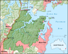
Ku-ring-gai Chase National Park is a national park on the northern side of Sydney in New South Wales, Australia. The 14,977-hectare (37,010-acre) park is 25 kilometres (16 mi) north of the Sydney Central Business District and generally comprises the land east of the M1 Pacific Motorway, south of the Hawkesbury River, west of Pittwater and north of Mona Vale Road. It includes Barrenjoey Headland on the eastern side of Pittwater.
Ku-ring-gai Chase is a popular tourist destination, known for its scenic setting on the Hawkesbury River and Pittwater, significant plant and animal communities, Aboriginal sites and European historic places. Picnic, boating, and fishing facilities can be found throughout the park. There are many walking tracks in Ku-ring-gai Chase. The villages of Cottage Point, Appletree Bay, Elvina Bay, Lovett Bay, Coasters Retreat, Great Mackerel Beach and Bobbin Head are located within the park boundaries.
The park was declared in 1894,[2] and is the third oldest national park in Australia.[3] The park is managed by the NSW National Parks and Wildlife Service and was added to the Australian National Heritage List in December 2006.[4]
The name "Ku-ring-gai" is an ethnonym referring to an aggregation of Indigenous Australian peoples occupying the territory between the southern borders of the Gamilaraay and the area around Sydney.
Geology[]

Ku-ring-gai Chase is part of the Hornsby Plateau, a massive block of sandstone tilting upwards to the north. The park comprises a plateau with an elevation of generally 150–200 m above sea level. The plateau is divided into separate sections by the steep valleys of Cowan Creek, Coal and Candle Creek, and Smiths Creek. These "flooded" or "drowned" valleys, knowns as rias, were eroded into the sandstone much deeper than the current sea level during the glacial phases of the Pleistocene ice age. When the ice caps melted about 10,000 years ago, the sea levels rose and flooded the valleys of the park.
The dominant rock type is Hawkesbury Sandstone which determines the topography and the vegetation in the sandy soils. Sandstone cliffs, rocky and outcrops, and worn caves are common throughout the park.
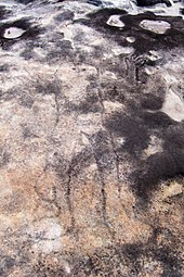
Indigenous people engraved the flat sandstone outcrops.
Tessellated pavements are found in the park whereby regular chequered patterns in the stone form along fault lines and lines of weakness.
Other rock types in the park are less common. Soils derived from the Narrabeen group of shales are around the eastern shore of the Lambert Peninsula, particularly around Elvina Bay and Lovett Bay. These richer soils provide for a vegetation type different from that of the sandy ridge top soils, providing for forests of spotted gums (Corymbia maculata) with forest oaks as a secondary layer. Eroded remnants of volcanic dykes occur including at Resolution Picnic Area at West Head and Campbells Crater near Cowan, which provide for forests of Sydney blue gum (Eucalyptus saligna).
The park's highest point is 246 m at Willunga Trig near West Head Road which runs along the ridge of the Lambert Peninsula.
History[]
Pre-European history[]
The name "Ku-ring-gai" (also spelled "Kuringgai", "Kuring-gai", "Guringai", "Kuriggai") (IPA: [kuriŋɡai],[5]) is an ethnonym referring to (a) an hypothesis regarding an aggregation of Indigenous Australian peoples occupying the territory between the southern borders of the Gamilaraay and the area around Sydney (b) perhaps an historical people with its own distinctive language, located in part of that territory, or (c) people of Aboriginal origin who identify themselves as descending from the original peoples denoted by (a) or (b) and who call themselves Guringai.
Little about the original inhabitants was recorded by Europeans at contact and their communities were soon destroyed through disease and conflict with European settlers.[6]
The national park contains extensive evidence of Aboriginal occupation of the area prior to European contact, across more than 800 sites in the park.[7] These include rock engravings, cave drawings, occupation sites, paintings and stencils, axe grinding grooves and middens providing significant evidence of the way of life of the Guringai people.
Park history[]
It was previously underdeveloped by early settlers due to poor accessibility and low soil fertility, except for some of the more fertile ridgetops. Sawmills were established in the 1830s, including at the upper reaches of Cowan Creek where Duffy's Wharf was built to transport logs.
The Pacific Highway and railway built along the ridgetop forming the park's current western border provided access to Cowan Creek along which pioneers settled. 40 hectares at Gerard Point, now Church Point, were granted to James Terry of Gordon.
Following pressure from a local citizen, Eccleston Du Faur, to establish a "National Park for North Sydney", approximately 13,500 hectares, including not only land areas but also most of Cowan Water, was set aside in 1894 as Ku-ring-gai Chase as a conservation area, and placed under the care, control and management of trustees.[2] It is the third oldest national park in Australia,[8] with the Royal National Park being the oldest.
Ku-ring-gai Chase became a national park with the proclamation of the National Parks and Wildlife Act in 1967.[citation needed] It is the third oldest national park in Australia,[9] with the Royal National Park being the oldest. Additions to the park have made it 14,882 hectares in size.[citation needed] The park is managed by the NSW National Parks and Wildlife Service and was added to the Australian National Heritage List in December 2006.[10] The term "chase" indicates it was an area of natural bush not enclosed by fences.[6] Ku-ring-gai Chase is also officially classed as a suburb by the Geographical Names Board of New South Wales.[11][12]
The television series, Skippy the Bush Kangaroo was shot in northern Sydney at Ku-ring-gai Chase National Park and the adjacent Waratah Park. Bushfires ravaged the park in January 1994.[2]
Locations, access and facilities[]
Many of the park's attractions are accessible only by walking track. Many kilometres of park front the southern shoreline of Broken Bay making it a good place to explore by boat.[2]
Rail access is provided at Mount Colah, Mount Kuring-gai, Berowra and Cowan railway stations.[2] All roads in the area are sealed and all have collection gates where a daily fee is payable.
Bobbin Head[]
Bobbin Head is located on Cowan Creek and facilities include a marina, picnic areas, a small store, and a lunch-time restaurant in what used to be the Bobbin Head Inn, which also contains an information centre. The area contains many fire trails and a walk through mangroves. Aboriginal engravings can be seen in the area.
Appletree Bay[]
- Paved parking area, including trailer parking
- Boat launch ramp and jetty
- Flush Toilets
- Picnic Tables
- Barbecues
The Basin[]
A popular camping and picnic site with a small beach is located at the Basin on Pittwater. This is the only place in the entire national park where camping is allowed.[2] Access is either by West Head Road via The Basin Track or on a ferry from Palm Beach Wharf.
West Head[]
West Head is a headland at the north eastern tip of the National Park. A lookout, with views of Barrenjoey, Palm Beach and Broken Bay]], has been built on West Head.[13] The Flint & Steel Guesthouse was one of the first buildings on West Head.
Barrenjoey[]
Barrenjoey is a locality of Palm Beach.[14] It is a headland and unusual amongst the National Park's features as it is not joined to the rest of the Park by land but separated by 1 kilometre of water, the Pittwater.
The Sphinx[]

This is a walk going by the Sphinx Memorial, which is a sandstone monument commemorating the fallen A.I.F comrades of Pte. William T. Shirley during World War I and was created by the returned soldier in the 1920s.[15][16] The Sphinx took about one and a half years to complete.[17]
The top inscription reads:
To my glorious comrades of the A.I.F
by the late W. Shirley
No 5756 Pte. 13th Battalion
Died 27th August 1929
The lower plaque's inscription reads:
This memorial, following restoration,
was rededicated on the 9th November 1995,
in recognition of the selflessness and sacrifices
of the members of the A.I.F.
Cottage Point[]
Cottage Point is Sydney's smallest locality and is listed as a heritage conservation area.[18] Cottage Point Kiosk and Boat Hire, built around 1918, is situated at Cottage Point at the entrance to Coal and Candle Creek.[19]
Jerusalem Bay[]
Jerusalem Bay is accessible by a track which is part of the Great North Walk from Cowan, New South Wales|Cowan railway station next to the Pacific Highway.[20] The track passes through a creek gorge lined with temperate rainforest and large turpentines before opening to the bay. At the bay is an old abandoned habitation site. It opens out to Cowan Water and Broken Bay making it popular with boating and fishing enthusiasts. After the bay the track proceeds up a steep climb past Campbell's Crater and along the ridge all the way to Brooklyn. Campbell's Crater is a volcanic diatreme containing subtropical rainforest species such as Red Cedars and Cabbage Palms with a floor of ferns.[21]
A plane accident occurred in the area on 31 December 2017, killing the pilot and five passengers.[22]
See also[]
- Church Point Ferry
- Pittwater Road
- Protected areas of New South Wales
- Sydney Rock Engravings
- Geography of Sydney
References[]
- ^ Jump up to: a b "Ku-ring-gai Chase National Park: Park management". Office of Environment and Heritage. Government of New South Wales. Archived from the original on 6 October 2014. Retrieved 6 October 2014.
- ^ Jump up to: a b c d e f Hema Maps (1997). Discover Australia's National Parks. Milsons Point, New South Wales: Random House Australia. pp. 116–7. ISBN 1-875992-47-2.
- ^ "National Heritage Places - Ku-ring-gai Chase National Park, Lion Island, Long Island and Spectacle Island nature reserves". Australian Government Department of Agriculture, Water and the Environment.
- ^ "Australian National Heritage listing for Ku-ring-gai Chase National Park, Lion Island, Long Island and Spectacle Island Nature Reserves". Department of the Environment. Australian Government. Archived from the original on 31 May 2013. Retrieved 23 March 2013.
- ^ Steele 2005.
- ^ Jump up to: a b "Ku-ring-gai Chase National Park and Lion Island, Long Island and Spectacle Island Nature Reserves, Plan of Management" (PDF). NSW Office of Heritage & Environment. NSW National Parks and Wildlife Service. p. 6. Retrieved 21 July 2019.
- ^ "Aboriginal heritage". Office of Environment and Heritage. Government of New South Wales. Archived from the original on 19 March 2011. Retrieved 7 May 2011.
- ^ "National Heritage Places - Ku-ring-gai Chase National Park, Lion Island, Long Island and Spectacle Island nature reserves". Australian Government Department of Agriculture, Water and the Environment.
- ^ "National Heritage Places - Ku-ring-gai Chase National Park, Lion Island, Long Island and Spectacle Island nature reserves". Australian Government Department of Agriculture, Water and the Environment.
- ^ "Australian National Heritage listing for Ku-ring-gai Chase National Park, Lion Island, Long Island and Spectacle Island Nature Reserves". Department of the Environment. Australian Government. Archived from the original on 31 May 2013. Retrieved 23 March 2013.
- ^ [1]
- ^ [https://maps.six.nsw.gov.au/?search={%22name%22:%22Suburb%22,%22fields%22:{%22suburbname%22:%22KU-RING-GAI%20CHASE%22}}
- ^ Gregory's Street Directory, 59th Edition 1995, Map 109
- ^ UBD Street Directory, 40th Edition 2003, Map 78
- ^ "Sphinx Memorial - Ku-ring-gai Chase National Park". Government of New South Wales. 2010. Archived from the original on 14 September 2009.
Pte. William Shirley was a patient of the Lady Davidson Convalescent Hospital...
- ^ "Sphinx Memorial". NSW National Parks. Retrieved 9 May 2019.
- ^ webadmin (11 April 2012). "Sphinx Memorial - Ku-ring-gai Chase National Park". www.warmemorialsregister.nsw.gov.au. Retrieved 10 May 2019.
- ^ "Cottage Point". www.visitsydneyaustralia.com.au. Retrieved 19 February 2020.
- ^ "Cottage Point Kiosk". www.cottagepointkiosk.com.au. Retrieved 10 May 2019.
- ^ "Jerusalem Bay Track (to Jerusalem Bay and back)". Wildwalks.com. Archived from the original on 26 March 2012.
- ^ "Cowan, Jerusalem Bay, Campbells Crater, Brooklyn". Wildwalks.com. Archived from the original on 29 March 2010.
- ^ Clun, Rachel (1 January 2018). "Hawkesbury River seaplane crash: New Year's Eve joy flight turns to tragedy for British tourists". Sydney Morning Herald. Retrieved 11 December 2018.
External links[]
| Wikimedia Commons has media related to Ku-ring-gai Chase National Park. |
- "Ku-ring-gai Chase National Park". NSW National Parks & Wildlife Service. Government of New South Wales.
- "Ku-ring-gai Chase National Park". Office of Environment and Heritage. Government of New South Wales.
- A comprehensive list of short bushwalks in Ku-Ring-Gai National Park
- "Ku-ring-gai Chase National Park". Bushwalking trails, mountain bike tracks and swimming spots. Hiking the World.
- Sydney Rock Art
- History of Commodore Heights [site of West Head Lookout]: Paul Ashton (2008). "Commodore Heights". Dictionary of Sydney. Retrieved 26 September 2015. [CC-By-SA] .
- Niall Clugston (2008). "Apple Tree Bay". Dictionary of Sydney. Retrieved 6 October 2015. [CC-By-SA] .
- Niall Clugston (2008). "Cowan Creek". Dictionary of Sydney. Retrieved 6 October 2015. [CC-By-SA] .
| show Hawkesbury River region, New South Wales, Australia |
|---|
| show Authority control |
|---|
- IUCN Category II
- National parks of New South Wales
- Protected areas established in 1967
- Rock art in Australia
- Australian National Heritage List
- 1894 establishments in Australia
- Hawkesbury River
- Hornsby Shire
- Asquith, New South Wales