Kudumbimalai
This article does not cite any sources. (October 2018) |
Kudumbimalai
குடும்பிமலை තොප්පිගල | |
|---|---|
 Kudumbimalai | |
 Kudumbimalai | |
| Coordinates: 7°52′0″N 81°32′0″E / 7.86667°N 81.53333°E | |
| Country | Sri Lanka |
| Province | Eastern |
| District | Batticaloa |
| DS Division | Koralai Pattu South |

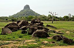
Kudumbimalai (Tamil: குடும்பிமலை; Sinhala: තොප්පිගල, Thoppigala) is a region in the west of Batticaloa District, Sri Lanka. It consists of a rock formation and a thick jungle. The area is very close to Polonnaruwa District border.
Kudumbimalai in Tamil translates to Hair-knot-rock. British colonists from the past named the rock Baron's Cap.
Kudumbimalai was under the control of the Liberation Tigers of Tamil Eelam and was strategically important to the organization. In 2007, the Sri Lankan army captured the town from the LTTE in the Battle of Thoppigala, and permanently evicted the LTTE from the Eastern Province.[1]
References[]
- ^ Gardner, Simon (11 July 2007). "Sri Lanka declares fall of rebel east, Tigers defiant". Reuters. Retrieved 7 January 2022.
This Eastern Province, Sri Lanka location article is a stub. You can help Wikipedia by . |
Categories:
- Eastern Province, Sri Lanka geography stubs
- Towns in Batticaloa District
- Koralaipattu South DS Division