Kumasi Metropolitan Assembly
Kumasi Metropolitan Assembly | |
|---|---|
Metropolitan District | |
 Aerial view of submetro Nhyiaeso in Kumasi Metropolitan Assembly (Kumasi Metropolis) in 2003 | |
 Flag | |
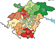
 Districts of Ashanti Region | |
 Kumasi Metropolitan Assembly Location of Kumasi Metropolitan Assembly within Ashanti | |
| Coordinates: 6°41′N 1°37′W / 6.683°N 1.617°W | |
| Country | |
| Region | |
| Capital | |
| Founded | 1680 |
| Founded by | King Asantehene Osei Tutu I |
| Seat | Kumasi Metropolis Hall |
| Submetros | |
| Government | |
| • Type | Mayor–council absolute monarchy |
| • Body | Manhyia Palace - Kumasi Metropolitan Assembly |
| • Metropolis Chief Executive | Osei Tutu II |
| • City Mayor | Osei Assibey Antwi (KMA/NPP) |
| Area | |
| • Total | 299 km2 (115 sq mi) |
| Population (2021 Census) | |
| • Total | 443,981[1] |
| Time zone | UTC+0 (GMT) |
| Website | www |


Kumasi Metropolitan Assembly (abbreviated as the KMA) is one of the 260 Metropolitan, Municipal and District Assemblies (MMDAs) in Ghana and forms part of the forty-three districts in Ashanti Region, Ghana with Kumasi being its administrative capital.[2] The metropolis is located in the central part of Ashanti Region and has Kumasi (the regional capital) as its capital city.[3]
History[]
The city of Kumasi was founded by King Osei Tutu I in the 1680s to serve as the capital of the Asante State [4][1]. Due to the location of Kumasi and its dominance in the politics of the Gold coast in the early days, Kumasi evolved into a major commercial hub with all the major trading routes across the country converging within it.[5] Unfortunately due to the colonial rule Kumasi also came under the British rule in 1890.[6] Kumasi grew with time and eventually evolved to become the second largest city in terms of land area, population size, economic activity and socio-economic lifestyle to Accra the largest in Ghana.[7]
Originally founded in 1680, "Kumasi" later then became known became known as the from 1988 until 1995, when it was upgraded into metropolitan assembly status.[8][2] Evolving around the three communities of Adum, Krobo and Bompata, Kumasi has eventually grown in a concentric form to cover an area of approximately ten (10) kilometers in radius. The direction of growth was originally and initially along the arterial roads due to the accessibility and permeability they offered resulting in a radial pattern of development.[9]
Location[]
The Kumasi Metropolitan is about 270 km north of the Accra, which is the national capital of Ghana, 120 km south east of Sunyani the capital of the Bono Region and it is located between Latitude 6.35° N and 6.40° S and Longitude 1.30° W and 1.35° E and elevated 250 to 300 meters above sea level.[3] It is located in the transitional forest zone.[9]
Structure[]
The Kumasi Metropolitan Assembly (KMA) was established by Legislative Instrument 1614 of 1995 under Local Government Law 1988, NDPC law 207, which replaced the Local Government Act 462, 1993. The LI 1614 of 1995 under the under Local Government Law 1988, NDPC law 207 established the Kumasi Metropolitan area and divided it into an initial 4 sub-metropolitan area[10] namely Asokwa, Bantama, Manhyia and Subin.[11] [3]
In 2005, The LI, 1914 which was amended as LI 1805, 2005 divided the Metropolitan Assembly into 10 Sub-Metropolitan District Councils namely Asawase, Asokwa, Bantama, Kwadaso, Manhyia, Nhyiaeso, Oforikrom, Suame, Subin and Tafo.[9][12]
In 2012, Asawase Sub-Metropolitan District Council was carved out from KMA to create the Asokore Mampong Municipal District Assembly through LI 2112.[4][13][14] Thus leaving the Kumasi Metropolis with nine sub-metropolitan districts councils. For effective administration, Kumasi Metropolises continuously worked in its divided 9 Sub-Metropolitan District Councils left namely Asokwa, Bantama, Kwadaso, Manhyia, Nhyiaeso, Oforikrom, Suame, Subin and Tafo.[15]
Later in 2017, five (5) former sub-metropolitan district councils were upgraded to municipal assembly status, which consist of the following: Asokwa Municipal District, Kwadaso Municipal District, Oforikrom Municipal District, Old Tafo Municipal District and Suame Municipal District.[16][17]
Administration[]
The political governance of the Metropolises vested in Kumasi Metropolitan Assembly (KMA). It is made up of the Metropolitan Chief Executive who is the head and also represents the central government, 136 Assembly members who have power to vote, Members of Parliament and heads of departments of the Assembly.[18]
The Metropolitan Chief Executive or the Mayor of Kumasi is appointed by the President and accepted by not less two-thirds of the General Assembly through voting.[19]
The current Metropolitan Chief Executive is Osei Assibey Antwi.[20]
References[]
- ^ Ghana: Administrative Division
- ^ Ghana Statistical Service (2014). District Analytical Report, Kumasi Metropolitan Assembly (PDF). Accra Ghana: Ghana Statistical Service.
- ^ a b "Ghana Districts: A repository of all Local Assemblies in Ghana (Kumasi Metropolitan Assembly)". ghanadistricts.com. Retrieved 2021-01-05.
- ^ Hagan, G. P. (1972). "Review of Asante and its Neighbours 1700-1807". Transactions of the Historical Society of Ghana. 13 (2): 292–295. ISSN 0855-3246. JSTOR 41406414.
- ^ Steel, Robert W. (1971-01-01). "A Historical Geography of Ghana. By Kwamina B. Dickson. Cambridge University Press, 1969. Pp. xiv+379, bibl., maps. £7. 10s". Africa. 41 (1): 78. doi:10.2307/1159698. ISSN 1750-0184. JSTOR 1159698.
- ^ Refugees, United Nations High Commissioner for. "Refworld | Chronology for Ashanti in Ghana". Refworld. Retrieved 2021-01-05.
- ^ Earth Institute, Columbia University. "Kumasi, Ghana - Millennium Cities Initiative". Retrieved 2021-01-05.
- ^ Ahwoi, Kwamena (November 2017). "The New Sub-metropolitan District Council Establishment Instrument: Lack of policy clarity or failure of legislative drafting?" (PDF). The IEA Legislative Alert. ISSN 0855-2460.
- ^ a b c Adarkwa, Kwasi Kwafo (2011). Future of the Tree: Towards Growth and Development of Kumasi. Kumasi, Ghana: University Printing Press (UPK) Knust. pp. 14–34. ISBN 978-9988-1-5451-6.
- ^ "Sub-Metropolitan District Councils, Section 18 - Establishment of Sub-Metropolitan Districts". www.judy.legal. Retrieved 2021-01-05.
- ^ Ahwoi, Kwamena (November 2017). "The New Sub-metropolitan District Council Establishment Instrument: Lack of policy clarity or failure of legislative drafting?" (PDF). The IEA Legislative Alert. ISSN 0855-2460.
- ^ Ahwoi, Kwamena (November 2017). "The New Sub-metropolitan District Council Establishment Instrument: Lack of policy clarity or failure of legislative drafting?" (PDF). The IEA Legislative Alert. ISSN 0855-2460.
- ^ "New Districts & Nominated DCEs" (PDF). ghanadistricts. Archived from the original (PDF) on 5 March 2013.
- ^ "Ghana Districts: A repository of all Local Assemblies in Ghana ( Asokore Mampong Municipal Assembly)". www.ghanadistricts.com. Retrieved 2021-01-05.
- ^ Ghana Statistical Service (2014). District Analytical Report, Kumasi Metropolitan Assembly (PDF). Accra Ghana: Ghana Statistical Service.
- ^ Allotey, Godwin Akweiteh (2017-11-17). "Full list of new districts, elevated ones". Citi 97.3 FM - Relevant Radio. Always. Retrieved 2021-01-05.
- ^ Godwin A. Allotey & Melvin Clottey (2017-11-18). "List of new districts, municipal assemblies [Infographic]". Citi 97.3 FM - Relevant Radio. Always. Retrieved 2021-01-05.
- ^ Ghana Statistical Service (2014). District Analytical Report, Kumasi Metropolitan Assembly (PDF). Accra Ghana: Ghana Statistical Service.
- ^ Local Governance Act, 2016 ,Act 936. Accra, Ghana: GPCL, Assembly Press. 20 December 2016. pp. 1–143.
- ^ Frimpong, Enoch Darfah (17 March 2017). "Kumasi mayor Osei Assibey Antwi gets 99 per cent endorsement". Graphic Online. Retrieved 2021-01-04.
Sources[]
External links[]
| Governance |
| ||||||||||||||||||||||||
|---|---|---|---|---|---|---|---|---|---|---|---|---|---|---|---|---|---|---|---|---|---|---|---|---|---|
| Geography |
| ||||||||||||||||||||||||
| Institutions |
| ||||||||||||||||||||||||
| Sports |
| ||||||||||||||||||||||||
| Transport |
| ||||||||||||||||||||||||
| Layouts | |||||||||||||||||||||||||
| Media |
| ||||||||||||||||||||||||
| Economy |
| ||||||||||||||||||||||||
| Healthcare |
| ||||||||||||||||||||||||
| |||||||||||||||||||||||||
- Kumasi
- Districts of Ashanti Region