Kume Island
Native name: クミジマ(Kumijima) | |
|---|---|
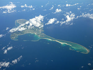 Kumejima Island 2009 | |
 | |
| Geography | |
| Location | Pacific Ocean |
| Coordinates | 26°20′28″N 126°48′18″E / 26.34111°N 126.80500°ECoordinates: 26°20′28″N 126°48′18″E / 26.34111°N 126.80500°E |
| Archipelago | Okinawa Islands |
| Area | 59.11 km2 (22.82 sq mi) |
| Administration | |
Japan | |
| Prefecture | Okinawa Prefecture |
| Demographics | |
| Population | 8,713 (2010) |
| Ethnic groups | Ryukyuan, Japanese |

Kume Island[1] (久米島, Kumejima, Okinawan: クミジマ Kumijima) is an island, part of the Okinawa Islands and administratively part of the town of Kumejima, Okinawa Prefecture, Japan. It has an area of 59.11 square kilometres (636,300,000 sq ft).[2] The island had a population of 8,713 (2010).
Kume Island is a volcanic island. Its principal economic activities are the production of sugarcane and tourism.[3]
References[]
- ^ Kerama Islands. Open Coast Travel.
- ^ "Archived copy". Archived from the original on 2011-07-25. Retrieved 2011-07-19.CS1 maint: archived copy as title (link)
- ^ "Kumejima". Encyclopedia of Japan. Tokyo: Shogakukan. 2013. OCLC 56431036. Archived from the original on 2007-08-25. Retrieved 2013-01-27.
| hide Authority control | |
|---|---|
| General | |
| National libraries | |
This Okinawa Prefecture location article is a stub. You can help Wikipedia by . |
Categories:
- Okinawa Islands
- Islands of Okinawa Prefecture
- Kumejima, Okinawa
- Okinawa geography stubs