Kutari River
| Kutari Cutari | |
|---|---|
 Armamatau, Kutari and Sipaliwini River, with Kutari as southern east border of the Tigri Area, map from 1930 | |
 | |
| Location | |
| Country | Suriname |
| Physical characteristics | |
| Mouth | Coeroeni River |
• location | Sipaliwini River |
• coordinates | 2°20′32″N 56°52′4″W / 2.34222°N 56.86778°WCoordinates: 2°20′32″N 56°52′4″W / 2.34222°N 56.86778°W |

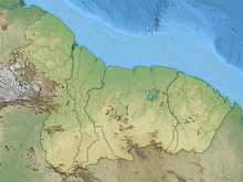
Kutari River, also called Cutari Rivier, Kutari Creek or Cutari Creek, is a small river at the South East of the Tigri Area in the extreme South of Suriname.[1]
The river has its source in the Acarai Mountains that border Brazil.[2] Together with the Sipaliwini River the Kutari flows out in the Coeroeni River, where the village of Kwamalasamutu is within ten kilometers eastwards as the crow flies.[3] To the north, the Kutari and the Coeroenie successively form the rivers on the eastern border of the Tigri Area.[4] According to Guyana, this is the frontier of both countries; according to Suriname the border must be drawn at the New River, which forms the west frontier of the Tigri Area.[2]
See also[]
References[]
- ^ Rand McNally, The New International Atlas, 1993
- ^ a b Ewan W. Anderson, International Boundaries: A Geopolitical Atlas, Guyana, page 37, ISBN 9781579583750, 2003
- ^ Dr. Eithne B. Carlin, Indianen in Suriname (in Dutch), Talen en Culturen van Indiaans Amerika (TCIA) / Leiden University Centre for Linguistics (LUCL)
- ^ Kevin H. De Cuba, Department for Sustainable Development (DSD) / The Organization of American States (OAS) , Towards Sustainable Energy production and use in the lands inhabited by the Trio and Wayana peoples in the Suriname-Brazil border, 4.3.1 Micro hydro power in Kwamalasamutu, page 52, 2003 (in Dutch)
Categories:
- Rivers of the Tigri Area