Kvalsund (village)
Kvalsund
Ráhkkerávju | |
|---|---|
Village | |
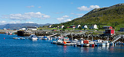 Part of the village | |
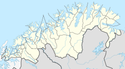 Kvalsund Location of the village | |
| Coordinates: 70°30′09″N 23°58′47″E / 70.50250°N 23.97972°ECoordinates: 70°30′09″N 23°58′47″E / 70.50250°N 23.97972°E | |
| Country | Norway |
| Region | Northern Norway |
| County | Troms og Finnmark |
| District | Vest-Finnmark |
| Municipality | Hammerfest |
| Area | |
| • Total | 0.29 km2 (0.11 sq mi) |
| Elevation | 2 m (7 ft) |
| Population (2017)[1] | |
| • Total | 288 |
| • Density | 993/km2 (2,570/sq mi) |
| Time zone | UTC+01:00 (CET) |
| • Summer (DST) | UTC+02:00 (CEST) |
| Post Code | 9620 Kvalsund |


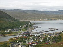
Kvalsund (Northern Sami: Ráhkkerávju) is a village in Hammerfest Municipality in Troms og Finnmark county, Norway. It was formerly the administrative centre of Kvalsund Municipality.
The village is located on the mainland, along the Kvalsundet strait, at the mouth of the river Kvalsundelva. The village sits just east of the Kvalsund Bridge which connects the mainland to the island of Kvaløya, just to the north. Kvalsund Church is located in this village.
The 0.29-square-kilometre (72-acre) village has a population (2017) of 288 which gives the village a population density of 993 inhabitants per square kilometre (2,570/sq mi).[1]
Kvalsund
References[]
- ^ Jump up to: a b c Statistisk sentralbyrå (1 January 2017). "Urban settlements. Population and area, by municipality".
- ^ "Kvalsund" (in Norwegian). yr.no. Retrieved 2013-01-26.
| Authority control |
|
|---|
This article about a location in Troms og Finnmark is a stub. You can help Wikipedia by . |
Categories:
- Villages in Finnmark
- Hammerfest
- Populated places of Arctic Norway
- Troms og Finnmark geography stubs