Lääne-Viru County
Lääne-Viru County
Lääne-Virumaa | |
|---|---|
 | |
 Coat of arms | |
 | |
| Country | Estonia |
| Capital | Rakvere |
| Area | |
| • Total | 3,695.72 km2 (1,426.93 sq mi) |
| Population (01.01.2018[1]) | |
| • Total | 59,791 |
| • Rank | 5th |
| • Density | 16/km2 (42/sq mi) |
| Ethnicity | |
| • Estonians | 87.4% |
| • Russians | 9% |
| • other | 3.6% |
| ISO 3166 code | EE-60 |
| Vehicle registration | R |
| Website | laane-viru |

Lääne-Viru County (Estonian: Lääne-Viru maakond or Lääne-Virumaa) is one of 15 counties of Estonia. It is in northern Estonia, on the south coast of the Gulf of Finland. In Estonian, lääne means western and ida means east or eastern. Lääne-Viru borders Ida-Viru County to the east, Jõgeva County to the south, and Järva and Harju counties to the west. In January 2013, Lääne-Viru County had a population of 58,806: 4.5% of the population in Estonia.[1]
History[]
In prehistoric times, Lääne-Virumaa was settled by Estonians of the Vironian tribe.
County Government[]
The County Government (Estonian: maavalitsus) is led by a governor (Estonian: maavanem), who is appointed by the Government of Estonia. Since 2014, the governor position has been held by Marko Torm. The county seat is Rakvere.
Municipalities[]
The county is subdivided into municipalities. There are one urban municipality (Estonian: linnad – towns) and seven rural municipalities (Estonian: vallad – parishes) in Lääne-Viru County.
| Rank | Municipality | Type | Population (2018)[2] |
Area km2[2] |
Density[2] |
|---|---|---|---|---|---|
| 1 | Haljala Parish | Rural | 4,389 | 547 | 8.0 |
| 2 | Kadrina Parish | Rural | 4,958 | 355 | 14.0 |
| 3 | Rakvere Parish | Rural | 5,566 | 296 | 18.8 |
| 4 | Rakvere | Urban | 15,613 | 11 | 1,419.4 |
| 5 | Tapa Parish | Rural | 11,252 | 479 | 23.5 |
| 6 | Vinni Parish | Rural | 6,919 | 1,013 | 6.8 |
| 7 | Viru-Nigula Parish | Rural | 5,981 | 311 | 19.2 |
| 8 | Väike-Maarja Parish | Rural | 6,016 | 683 | 8.8 |
Geography[]
This section is empty. You can help by . (July 2010) |
Gallery[]

Porkuni Castle gate tower

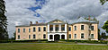
Palmse manor

Rakvere Castle
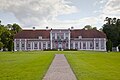
Mõdriku manor

Malla manor

Vihula windmill

Laekvere pine

Lake Neeruti Tagajärv

View from tower on the hill of Emumägi

Toolse Castle
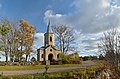
Vainupea Chapel
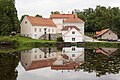
Vihula Manor

Altja river
Sagadi manor

Viru bog in Lahemaa National Park

Mähu boulders in Lahemaa National Park

Rapeseed field near Laekvere


References[]
- ^ Jump up to: a b "Population by sex, ethnic nationality and County, 1 January". stat.ee. Statistics Estonia. 1 January 2009. Retrieved 2009-10-18.
- ^ Jump up to: a b c "Elanike demograafiline jaotus maakonniti". Kohaliku omavalitsuse portaal. Archived from the original on 2 March 2019. Retrieved 2 April 2018.
External links[]
| Wikimedia Commons has media related to Lääne-Viru County. |
- Lääne-Viru County Government – Official website
- Lääne-Virumaa County Infoserver – map and tourism info
| show Geographic locale |
|---|
Coordinates: 59°15′N 26°20′E / 59.250°N 26.333°E

| show Authority control |
|---|
- Lääne-Viru County
- Counties of Estonia