Låtefossen
| Låtefossening | |
|---|---|
 The two joining streams Photo: Knud Knudsen, around 1900 | |
 | |
| Location | Vestland, Norway |
| Coordinates | 59°56′54″N 6°35′19″E / 59.948359°N 6.588498°ECoordinates: 59°56′54″N 6°35′19″E / 59.948359°N 6.588498°E |
| Type | Segmented Steep Cascade |
| Elevation | 335 metres (1,099 ft) |
| Total height | 165 metres (541 ft) |
| Number of drops | 1 |
| Longest drop | 52 metres (171 ft) |
| Average width | 23 metres (75 ft) |
| Run | 274 metres (899 ft) |
| Watercourse | Austdølo |
| Average flow rate | 17 cubic metres per second (600 cu ft/s) |


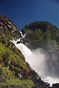
Låtefossen or Låtefoss is a waterfall located in Ullensvang Municipality in Vestland County, Norway. The 165-metre (541 ft) tall waterfall is unique and thus it is a well-known tourist attraction in the area. It is special in that it consists of two separate streams flowing down from the lake , and as they fall, they join in the middle of the waterfall, just before going under the Norwegian National Road 13 built in 1867–69, making for a spectacular (and wet) view as one drives over the old, stone, six-arched bridge.[1][2]
Gallery[]

View of the bridge

Section from Låtefossen

View of the falls

View of the visitors' center


See also[]
- List of waterfalls#Norway
 Media related to Låtefossen at Wikimedia Commons
References[]
- ^ "Låtefossen". World Waterfall Database.
- ^ Store norske leksikon. "Låtefoss" (in Norwegian). Retrieved 2014-06-17.
This Vestland location article is a stub. You can help Wikipedia by . |
Categories:
- Ullensvang
- Waterfalls of Vestland
- Vestland geography stubs