Lújar
This article does not cite any sources. (December 2009) |
Lújar, Spain | |
|---|---|
 Flag  Seal | |
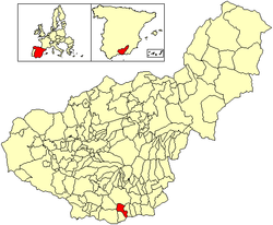 Location of Lújar | |
| Coordinates: 36°47′15″N 3°24′5″W / 36.78750°N 3.40139°WCoordinates: 36°47′15″N 3°24′5″W / 36.78750°N 3.40139°W | |
| Country | Spain |
| Province | Granada |
| Municipality | Lújar |
| Area | |
| • Total | 36 km2 (14 sq mi) |
| Elevation | 895 m (2,936 ft) |
| Population (2018)[1] | |
| • Total | 462 |
| • Density | 13/km2 (33/sq mi) |
| Time zone | UTC+1 (CET) |
| • Summer (DST) | UTC+2 (CEST) |

Lújar is a village in southern Spain in the Sierra Nevada, a couple of kilometres inland from the coast and the city of Motril along a fairly precipitous road. Its coordinates are 36°47′15″N 3°24′5″W / 36.78750°N 3.40139°W (36.7877, -3.4016). Its population is approximately 1,200.
History[]
The village was one of the first to be taken during the Spanish Civil War.
Facilities[]
There is a municipal open air swimming pool at the western end of the village, and a couple of bars.
References[]
- ^ Municipal Register of Spain 2018. National Statistics Institute.
This article about a location in the province of Granada is a stub. You can help Wikipedia by . |
Categories:
- Populated places in the Province of Granada
- Province of Granada geography stubs