La Coulée, les Saintes
Pompierre | |
|---|---|
Quartier | |
 | |
| Coordinates: 15°52′11″N 61°34′46″W / 15.86972°N 61.57944°WCoordinates: 15°52′11″N 61°34′46″W / 15.86972°N 61.57944°W | |
| Country | |
| Overseas department | |
| Canton | les Saintes |
| commune | Terre-de-Haut |

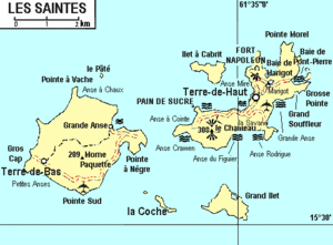
La Coulée is a quartier of Terre-de-Haut Island, located in Îles des Saintes archipelago in the Caribbean. It is located in the northeastern part of the island.
This Guadeloupe location article is a stub. You can help Wikipedia by . |
Categories:
- Populated places in Îles des Saintes
- Quartiers of Îles des Saintes
- Guadeloupe geography stubs