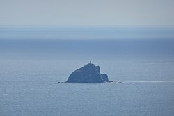
La Monja Island
 | |
 | |
| Geography | |
|---|---|
| Location | Manila Bay |
| Coordinates | 14°22′32″N 120°31′19″E / 14.37556°N 120.52194°ECoordinates: 14°22′32″N 120°31′19″E / 14.37556°N 120.52194°E |
| Adjacent bodies of water | South China Sea |
| Administration | |
| Region | Calabarzon |
| Province | Cavite |
| City | Cavite City |
| Demographics | |
| Population | uninhabited |

La Monja Island (also Monja Island; Spanish: "the nun") is a small, uninhabited island near the entrance to Manila Bay in the Philippines. It is located several kilometers southeast of Mariveles, Bataan, and 6.0 kilometres (3.7 mi) west from Corregidor lighthouse.[1] It has remained untouched compared to other nearby islands, which have been used as military installations over the past four centuries.
History[]
On 18 May 2012, a pilot and co-pilot were killed when an Aermacchi SF.260 plane belonging to the Philippine Air Force crashed close to the island.[2]
See also[]
- List of islands in the Greater Manila Area
- List of islands of the Philippines
- List of islands
- Desert island
References[]
- ^ Berhow, Mark (20 Sep 2012). American Defenses of Corregidor and Manila Bay: 1898-1945. London: Osprey Publishing. p. 5. ISBN 9781782004356. Retrieved 25 February 2016.
- ^ "Debris, human foot found after Philippine military plane crashes". BNO News. 19 May 2012. Retrieved 19 May 2012.
This article about a location in Calabarzon region is a stub. You can help Wikipedia by . |
Categories:
- Islands of Manila Bay
- Uninhabited islands of the Philippines
- Islands of Cavite
- Cavite City
- Calabarzon geography stubs