La Mott, Pennsylvania
La Mott
Camp Town | |
|---|---|
Unincorporated community Neighborhood of Cheltenham Township | |
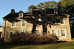
 La Mott, corner of Willow Avenue and Sycamore Avenue. September 2012. | |
 La Mott Location of La Mott in Pennsylvania | |
| Coordinates: 40°04′04″N 75°08′26″W / 40.06778°N 75.14056°WCoordinates: 40°04′04″N 75°08′26″W / 40.06778°N 75.14056°W | |
| Country | United States |
| State | Pennsylvania |
| County | Montgomery |
| Township | |
| Commissioner | Harvey Portner |
| Area | |
| • Total | .261 sq mi (0.68 km2) |
| • Land | .261 sq mi (0.68 km2) |
| • Water | 0.00 sq mi (0.0 km2) |
| Elevation | 230 ft (70 m) |
| Population (2010) | |
| • Total | 3,554 |
| • Density | 14,000/sq mi (5,300/km2) |
| Time zone | UTC-5 (Eastern Standard Time) |
| • Summer (DST) | UTC-4 (Eastern Daylight Time) |
| Area code(s) | 215, 267 and 445 |
| Website | 66 |
| Official name | Village of La Mott |
| Designated | June 1973 |


La Mott is an unincorporated residential community in Cheltenham Township, Montgomery County, Pennsylvania, United States. It borders Philadelphia along Cheltenham Avenue.
The name honors Lucretia Mott, who lived here from the 1850s to her death in 1880.[1] Her house, Roadside, was a major stop on the Underground Railroad. There are 65 locations in the continental United States named Mott, but this is the only one named La Mott. La Mott has the ZIP code of 19027.
Formerly known as Camp Town, La Mott was the site of Camp William Penn, the first federal training site for black soldiers during the Civil War.
Gallery[]
|


See also[]
References[]
- ^ "Cheltenham Township: La Mott Historic District". Retrieved 17 October 2020.
External links[]
| Wikimedia Commons has media related to La Mott, Pennsylvania. |
Cheltenham Township, Montgomery County, Pennsylvania, Pennsylvania | ||
|---|---|---|
Founded 1682 | ||
| Communities |
|     |
| Education |
| |
| National Historic Sites | ||
| People |
| |
| See also |
| |
| Historical railroads |
| |
| Regional rail lines |
| |
| Regional rail stations | ||
| SEPTA bus routes |
| |
| Infrastructure | ||
| ||

This Montgomery County, Pennsylvania state location article is a stub. You can help Wikipedia by . |
- Unincorporated communities in Montgomery County, Pennsylvania
- Unincorporated communities in Pennsylvania
- Populated places on the Underground Railroad
- Cheltenham Township, Pennsylvania
- Montgomery County, Pennsylvania geography stubs