La Oliva
This article needs additional citations for verification. (April 2014) |
La Oliva | |
|---|---|
Municipality | |
 Flag  Coat of arms | |
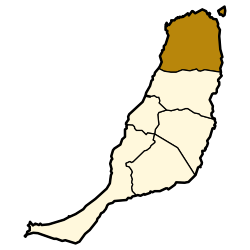 Municipal location in Fuerteventura | |
 La Oliva Location in the province of Las Palmas | |
| Coordinates: 28°36′40″N 13°55′40″W / 28.61111°N 13.92778°WCoordinates: 28°36′40″N 13°55′40″W / 28.61111°N 13.92778°W | |
| Country | Spain |
| Autonomous Community | Canary Islands |
| Province | Las Palmas |
| Island | Fuerteventura |
| Area | |
| • Total | 356.13 km2 (137.50 sq mi) |
| Population (2018)[2] | |
| • Total | 25,884 |
| • Density | 73/km2 (190/sq mi) |


La Oliva (pronounced [la oliˈβa]) is a town and a municipality in the northern part of the island of Fuerteventura in the Province of Las Palmas, Canary Islands, Spain. The population is 25,083 (2013),[3] and the area is 356.13 km².[1] The municipality includes the Lobos Island to the northeast. The largest town of the municipality, Corralejo, is a port town and beach resort at the northernmost point of the island. La Oliva is the historic seat of the island's Colonels, who resided in the stately Casa de los Coroneles. Because of this, La Oliva succeeded the Villa de Betancuria as the capital of Fuerteventura from 1834 until 1860, when Puerto Cabras became the new capital.
An anonymous manuscript relates that the town of La Oliva was founded in 1500 by individuals known to the Hernández brothers, residents of Betancuria.
Gallery[]

"Montaña Quemada" Canyon

A stone-built windmill near the beach of La Oliva

Church of Our Lady of La Candelaria

Corralejo beach

Los Lobos Island
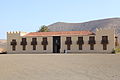
Casa de los Coroneles, La Oliva


See also[]
References[]
- ^ Jump up to: a b Instituto Canario de Estadística, area
- ^ Municipal Register of Spain 2018. National Statistics Institute.
- ^ Instituto Canario de Estadística Archived 2014-04-19 at the Wayback Machine, population
External links[]
| Wikimedia Commons has media related to La Oliva. |
| show Places adjacent to La Oliva |
|---|
| show Authority control |
|---|
This Canary Islands location article is a stub. You can help Wikipedia by . |
- Municipalities in Fuerteventura
- Populated places established in 1500
- Canary Islands geography stubs