La Rouxière
La Rouxière | |
|---|---|
Part of Loireauxence | |
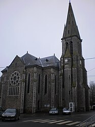 The church in La Rouxière | |
 Coat of arms | |
Location of La Rouxière  | |
 La Rouxière | |
| Coordinates: 47°26′37″N 1°03′59″W / 47.4436°N 1.0664°WCoordinates: 47°26′37″N 1°03′59″W / 47.4436°N 1.0664°W | |
| Country | France |
| Region | Pays de la Loire |
| Department | Loire-Atlantique |
| Arrondissement | Ancenis |
| Canton | Ancenis |
| Commune | Loireauxence |
| Area 1 | 20.96 km2 (8.09 sq mi) |
| Population (2019)[1] | 1,168 |
| • Density | 56/km2 (140/sq mi) |
| Demonym(s) | Rouxièroises, Rouxièrois |
| Time zone | UTC+01:00 (CET) |
| • Summer (DST) | UTC+02:00 (CEST) |
| Postal code | 44370 |
| Elevation | 23–78 m (75–256 ft) |
| Website | www.communelarouxiere.com |
| 1 French Land Register data, which excludes lakes, ponds, glaciers > 1 km2 (0.386 sq mi or 247 acres) and river estuaries. | |


La Rouxière is a former commune in the Loire-Atlantique department in western France. On 1 January 2016, it was merged into the new commune of Loireauxence.[2]
See also[]
- Communes of the Loire-Atlantique department
| Wikimedia Commons has media related to La Rouxière. |
References[]
This Loire-Atlantique geographical article is a stub. You can help Wikipedia by . |
Categories:
- Former communes of Loire-Atlantique
- Populated places disestablished in 2016
- Loire-Atlantique geography stubs