Lac qui Parle
| Lac qui Parle | |
|---|---|
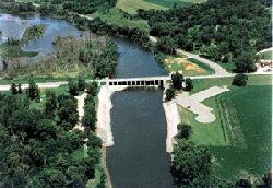 Dam located on the southern tip. Source: US Army Corps of Engineers | |
 Lac qui Parle | |
| Location | Chippewa County, Lac qui Parle County and Swift County, Minnesota United States |
| Coordinates | 45°6′N 95°59′W / 45.100°N 95.983°WCoordinates: 45°6′N 95°59′W / 45.100°N 95.983°W |
| Type | reservoir |
| Primary inflows | Minnesota River |
| Primary outflows | Minnesota River |
| Basin countries | United States |


Lac qui Parle is a reservoir located in western Minnesota, United States, which was formed by the damming of the Minnesota River. The dam was built by the Works Progress Administration (WPA) in 1939. It was reconstructed in 1996. Lac qui Parle is a French translation of the native Dakota name, meaning "lake which speaks".[1][2]
The northernmost point of the lake is about 3 miles southeast of the city of Appleton. The lake flows 10 miles southeast to the dam, which is about 4 miles to the west of the town of Watson.
Lac qui Parle State Park is located on the southern portion of the lake. Lac qui Parle serves as a temporary home of thousands of migratory Canada geese and other waterfowl.
| Wikimedia Commons has media related to Lac qui Parle. |
References[]
- ^ Gannett, Henry (1905). The Origin of Certain Place Names in the United States. Government Printing Office. pp. 178.
- ^ "Lac qui Parle State Park".
External links[]
Categories:
- Lakes of Chippewa County, Minnesota
- Lakes of Lac qui Parle County, Minnesota
- Lakes of Swift County, Minnesota
- Reservoirs in Minnesota
- Minnesota River
- Works Progress Administration in Minnesota
- Minnesota geography stubs