Laidi Parish
Laidi Parish | |
|---|---|
parish of Latvia | |
 Coat of arms | |
 | |
| Country | Latvia |
| Area | |
| • Total | 114.88 km2 (44.36 sq mi) |
| • Land | 110.71 km2 (42.75 sq mi) |
| • Water | 4.17 km2 (1.61 sq mi) |
| Population (1 January 2021)[2] | |
| • Total | 937 |
| • Density | 8.2/km2 (21/sq mi) |

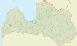
Laidi Parish (Latvian: Laidu pagasts) is an administrative unit of Kuldīga Municipality in the Courland region of Latvia. The parish has a population of 1274 (as of 1/07/2010) and covers an area of 114.97 km2.
Villages of Laidi parish[]
- Laidi
- Rude
- Sermite
- Valtaiķi
- Vanga
External links[]
This Courland location article is a stub. You can help Wikipedia by . |
- ^ https://data.stat.gov.lv/pxweb/lv/OSP_PUB/START__ENV__DR__DRT/DRT010/; Central Statistical Bureau of Latvia; retrieved: 26 February 2021.
- ^ https://data.stat.gov.lv/pxweb/lv/OSP_PUB/START__POP__IR__IRS/IRD060/; Central Statistical Bureau of Latvia; retrieved: 15 June 2021.
Categories:
- Parishes of Latvia
- Kuldīga Municipality
- Courland
- Courland geography stubs