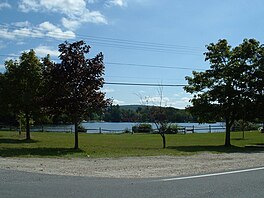
Lake Garfield
| Lake Garfield | |
|---|---|
 | |
 Lake Garfield | |
| Location | Berkshire County, Massachusetts, U.S. |
| Coordinates | 42°10′59″N 73°11′53″W / 42.183°N 73.198°WCoordinates: 42°10′59″N 73°11′53″W / 42.183°N 73.198°W |
| Type | Reservoir[1] |
| Basin countries | United States |
| Surface area | 275 acres (111 ha)[2] |
| Average depth | 16 ft (4.9 m)[2] |
| Max. depth | 35 ft (11 m)[2] |
| Surface elevation | 1,283 ft (391 m)[1] |
| Dam | Lake Garfield Dam[3] |
| Settlements | Monterey |


Lake Garfield is a 275-acre (111 ha) lake located about 0.5 miles (0.80 km) north of the center of Monterey, off Route 23 in Berkshire County, Massachusetts.
Overview[]
At the furthest western point of the lake near Tyringham Road, a public boat ramp and parking lot can be found. The town of Monterey makes these amenities unavailable during the period of June 15 through September 6 because of swimming season.[2] A 1979 survey recorded a total of 12 species of fish inside Lake Garfield: smallmouth bass, largemouth bass, pumpkinseed, yellow perch, chain pickerel, rainbow trout, golden shiner, brown bullhead, bluegill, white sucker, rock bass and white perch.[2] Lake Garfield is a popular fishing site for rainbow trout during spring. Due to the dominant yellow and white perch population, gamefish are usually below average size and abundance although a good bass or pickerel may occasionally be produced by the lake.[2]
Lake Garfield was named for a local family.[4]
References[]
- ^ a b U.S. Geological Survey Geographic Names Information System: Lake Garfield
- ^ a b c d e f Lake Garfield Pond map and info. MassWildlife. Retrieved June 22, 2018.
- ^ U.S. Geological Survey Geographic Names Information System: Lake Garfield Dam
- ^ Gannett, Henry (1905). The Origin of Certain Place Names in the United States. Govt. Print. Off. pp. 134.
This Berkshire County, Massachusetts geography–related article is a stub. You can help Wikipedia by . |
- Reservoirs in Massachusetts
- Lakes of Berkshire County, Massachusetts
- Berkshire County, Massachusetts geography stubs