Langenaubach
show This article may be expanded with text translated from the corresponding article in German. (April 2017) Click [show] for important translation instructions. |
Langenaubach | |
|---|---|
part of Haiger | |
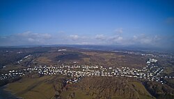 Langenaubach from above | |
 Coat of arms | |
show Location of Langenaubach | |
 Langenaubach | |
| Coordinates: 50°42′58″N 8°1′02″E / 50.71611°N 8.01722°ECoordinates: 50°42′58″N 8°1′02″E / 50.71611°N 8.01722°E | |
| Country | Germany |
| State | Hesse |
| Admin. region | Gießen |
| District | Lahn-Dill-Kreis |
| Town | Haiger |
| Area | |
| • Total | 9.87 km2 (3.81 sq mi) |
| Elevation | 360 m (1,180 ft) |
| Population (2016-06-30) | |
| • Total | 1,641 |
| • Density | 170/km2 (430/sq mi) |
| Time zone | UTC+01:00 (CET) |
| • Summer (DST) | UTC+02:00 (CEST) |
| Postal codes | 35708 |
| Dialling codes | 02773 |
| Vehicle registration | LDK |


Langenaubach is a village and a municipal district of Haiger in the Lahn-Dill-Kreis district in Hesse in Germany.
There are 1641 inhabitants, of which 65,5% are Protestant and 10,2% are Catholic. There was a mine called "Constanze" in Langenaubach
Geography[]
Location[]
Langenaubach lies about 3 km south of Haiger, and approx. 20 km southeast of Siegen on the eastern edge of the Westerwald range, near where the three states of Hesse, North Rhine-Westphalia and Rhineland-Palatinate all share a common point. The brook Aubach flows through this village.
Neighbouring communities[]
To the Northwest Langenaubach borders with the villages of and Niederdresselndorf, to the North with the town of Haiger and the village of , to the East with the village of , to the Southeast with the village of , to the South with the village of , to the Southwest with the village of .
References[]
| Authority control |
|---|
- Villages in Hesse
- Duchy of Nassau